Colwyn, Pennsylvania
| Colwyn, Pennsylvania | |
| Borough | |
|
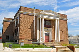
Colwyn Elementary School
|
|
| Country | United States |
|---|---|
| State | Pennsylvania |
| County | Delaware |
| Elevation | 59 ft (18.0 m) |
| Coordinates | 39°54′47″N 75°15′12″W / 39.91306°N 75.25333°WCoordinates: 39°54′47″N 75°15′12″W / 39.91306°N 75.25333°W |
| Area | 0.3 sq mi (0.8 km2) |
| - land | 0.3 sq mi (1 km2) |
| - water | 0.0 sq mi (0 km2), 0% |
| Population | 2,546 (2010) |
| Density | 8,486.7/sq mi (3,276.7/km2) |
| Mayor | Michael Blue |
| Timezone | EST (UTC-5) |
| - summer (DST) | EDT (UTC-4) |
| Area code | 610 |
|
Location in Delaware County and the state of Pennsylvania.
|
|
|
Location of Pennsylvania in the United States
|
|
|
Website: www |
|
Colwyn is a borough in Delaware County, Pennsylvania, United States. The population was 2,546 at the 2010 census.
Colwyn is located along the eastern border of Delaware County at 39°54′47″N 75°15′12″W / 39.91306°N 75.25333°W (39.913062, -75.253409), where Darby Creek and Cobbs Creek intersect. It is bordered to the north by the borough of Darby, to the west across Darby Creek by the borough of Sharon Hill, to the south across Cobbs Creek by a small portion of Darby Township, and to the east across Cobbs Creek by the city of Philadelphia.
The Darby station on the SEPTA Wilmington/Newark Line is on Pine Street in Darby, just west of the Colwyn border.
According to the United States Census Bureau, the borough has a total area of 0.26 square miles (0.67 km2), all of it land.
As of the census of 2000, there were 2,453 people, 850 households, and 602 families residing in the borough. The population density was 9,600.3 people per square mile (3,642.7/km²). There were 954 housing units at an average density of 3,733.7 per square mile (1,416.7/km²). The racial makeup of the borough was 42.64% White, 52.14% African American, 0.12% Native American, 0.98% Asian, 0.69% from other races, and 3.42% from two or more races. Hispanic or Latino of any race were 1.63% of the population.
...
Wikipedia


