Columbia, Mississippi
| Columbia, Mississippi | |
|---|---|
| City | |

Marion County courthouse in Columbia
|
|
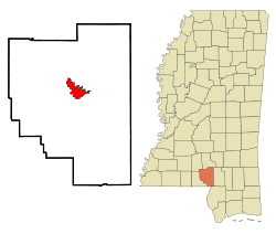
 Location of Columbia, Mississippi |
|
| Location in the United States | |
| Coordinates: 31°15′24″N 89°49′44″W / 31.25667°N 89.82889°WCoordinates: 31°15′24″N 89°49′44″W / 31.25667°N 89.82889°W | |
| Country | United States |
| State | Mississippi |
| County | Marion |
| Area | |
| • Total | 6.4 sq mi (16.6 km2) |
| • Land | 6.4 sq mi (16.5 km2) |
| • Water | 0.0 sq mi (0.0 km2) |
| Elevation | 148 ft (45 m) |
| Population (2000) | |
| • Total | 6,603 |
| • Density | 1,033.5/sq mi (399.0/km2) |
| Time zone | Central (CST) (UTC-6) |
| • Summer (DST) | CDT (UTC-5) |
| ZIP code | 39429 |
| Area code(s) | 601 |
| FIPS code | 28-15340 |
| GNIS feature ID | 0668715 |
Columbia is a city in Marion County, Mississippi, which was formed six years before Mississippi was admitted to statehood. Columbia was named for Columbia, South Carolina, from which many of the early settlers had migrated. The population was 6,603 as of the 2000 census. It is the county seat of Marion County.
Columbia is the county seat of Marion County, Mississippi. Marion county was created out of Amite county in 1811, encompassing the southwest quarter of the current state of Mississippi. Before statehood in 1816, there were three territorial census/poll tax records taken of what was deemed Marion County at the time. These records reveal that during 1813, several LOTT men arrived and settled on the Pearl River in what is now Columbia. In 1813, William Lot was the largest slave holder near present-day Columbia, owning 28 slaves. There were five men, who settled south of present-day Columbia on 2,789 acres of land with 65 slaves. North of present-day Columbia, on what was the earliest attempt at a town, was Timothy Terrell on 3,151 acres with 32 slaves.
The land on which the current City of Columbia resides was first purchased for cash on April 18, 1820,by William Lott and John Lott. This land is Township 3 East, Range 18 West, Section 5 (640 acres),which is the center of the City of Columbia today. Other early patent holders of Columbia include James Phillips, Jr., and John Cooper (1825),in Section 4 next to John and William Lott.
Columbia was officially incorporated on June 25, 1819, becoming the fourth municipality in the state of Mississippi. It served as the temporary capital of Mississippi from November, 1821, when the 5th session of the Mississippi Legislature first met there, until 1822. In that year, a special session of the legislature met in Columbia, inaugurating Governor Walter Leake, and selecting LeFleur's Bluff (now Jackson) as the permanent capital.[1].
Columbia, "The City of Charm on the River Pearl", has always been in danger of flooding, due to its bordering the Pearl River. The county courthouse, and records dating back to pre-statehood, has managed to survive war, floods, tornadoes and hurricanes. In its first 100 years, Columbia relied on the Pearl River for transportation of goods. The river was much deeper and wider than it is now. Steamboat captains, such as John Black, lived in Columbia.
...
Wikipedia

