Columbia, Kentucky
| City | |

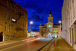
Adair County Courthouse
|
|
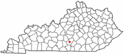
 Location of Columbia, Kentucky |
|
| Coordinates: 37°6′2″N 85°18′22″W / 37.10056°N 85.30611°WCoordinates: 37°6′2″N 85°18′22″W / 37.10056°N 85.30611°W | |
| Country | United States |
| State | Kentucky |
| County | Adair |
| Government | |
| • Type | Mayor-Council |
| • Mayor | Curtis Hardwick |
| • City Attorney | Marshall Loy |
| • Governing body | Columbia Council |
| Area | |
| • Total | 3.4 sq mi (8.9 km2) |
| • Land | 3.4 sq mi (8.9 km2) |
| • Water | 0.0 sq mi (0.0 km2) |
| Elevation | 748 ft (228 m) |
| Population (2010) | |
| • Total | 4,452 |
| • Density | 1,309.4/sq mi (505.6/km2) |
| Time zone | Central (CST) (UTC-6) |
| • Summer (DST) | CDT (UTC-5) |
| ZIP codes | 42715, 42728, 42735 |
| Area code(s) | 270 & 364 |
| FIPS code | 21-16750 |
| GNIS feature ID | 0489885 |
| Website | www.cityofcolumbiaky.com |
Columbia is a home rule-class city just above Russell Creek in Adair County, Kentucky, in the United States. The population was 4,452 at the 2010 census. Columbia is the seat of its county.
The area was settled c. 1802 by Daniel Trabue. The post office was opened on April 1, 1806, by John Field, who also ran the local store.
Columbia is located at 37°6′2″N 85°18′22″W / 37.10056°N 85.30611°W (37.100652, -85.306056).
According to the United States Census Bureau, the city has a total area of 3.4 square miles (8.9 km²), all land.
As of the census of 2000, there were 4,014 people, 1,554 households, and 893 families residing in the city. The population density was 1,167.9 per square mile (450.9/km2). There were 1,789 housing units at an average density of 520.5 per square mile (201.0/km2). The racial makeup of the city was 90.38% White, 7.37% African American, 0.22% Native American, 0.60% Asian, 0.02% Pacific Islander, 0.20% from other races, and 1.20% from two or more races. Hispanic or Latino of any race were 1.02% of the population.
...
Wikipedia
