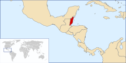
Colony of British Honduras
| British Honduras (1862–1973) Belize (1973–1981) |
||||||||||
| British colony | ||||||||||
|
||||||||||
Anthem
|
||||||||||
| Capital |
|
|||||||||
| Languages | English, Spanish, Belizean Creole, Garifuna, Mayan languages | |||||||||
| Government | Crown colony (monarchy) | |||||||||
| History | ||||||||||
| • | Settled | 1638 | ||||||||
| • | Crown colony | 1862 | ||||||||
| • | Self-governing | 1 January 1964 | ||||||||
| • | Renamed | 1 June 1973 | ||||||||
| • | Independence | 21 September 1981 | ||||||||
| Area | 22,966 km2 (8,867 sq mi) | |||||||||
| Population | ||||||||||
| • | 1861 est. | 25,635 | ||||||||
| Currency | British Honduran dollar | |||||||||
|
||||||||||
British Honduras was the name of a territory on the east coast of Central America, south of Mexico, after it became a British Crown colony in 1862. British Honduras became a self-governing colony in 1964, was renamed Belize in June 1973, and gained full independence in September 1981. British Honduras was the last continental possession of the United Kingdom in the Americas.
The colony grew out of the Treaty of Versailles (1783) between Britain and Spain, which gave the British rights to cut logwood between the Hondo and Belize rivers. The Convention of London (1786) expanded this concession to include the area between the Belize and Sibun rivers. In 1862, the Settlement of Belize in the Bay of Honduras was declared a British colony called British Honduras, and the Crown's representative was elevated to a lieutenant governor, subordinate to the governor of Jamaica.
As the British consolidated their settlement and pushed deeper into the interior in search of mahogany in the late 18th century, they encountered resistance from the Maya. In the second half of the 19th century, however, a combination of events outside and inside the colony redefined the position of the Maya.
During the Caste War in Yucatán, a devastating struggle that halved the population of the area between 1847 and 1855, thousands of refugees fled to the British settlement. The Legislative Assembly had given large landowners in the colony firm titles to their vast estates in 1855 but did not allow the Maya to own land. The Maya could only rent land or live on reservations. Nevertheless, most of the refugees were small farmers who, by 1857, were growing considerable quantities of sugar, rice, corn, and vegetables in the Northern District (now Corozal and Orange Walk districts). In 1857 the town of Corozal, then six years old, had 4,500 inhabitants, second in population only to Belize Town, which had 7,000 inhabitants. Some Maya who had fled the strife in the north but had no wish to become British subjects settled in the remote Yalbac Hills, just beyond the woodcutting frontier in the northwest. By 1862 about 1,000 Maya established themselves in ten villages in this area, with the center in San Pedro. One group of Maya, led by Marcos Canul, attacked a mahogany camp on the Bravo River in 1866, demanding ransom for their prisoners and rent for their land. A detachment of British troops sent to San Pedro was defeated by the Maya later that year. Early in 1867, more than 300 British troops marched into the Yalbac Hills and destroyed the Mayan villages, provision stores, and granaries in an attempt to drive them out of the district. The Maya returned, however, and in April 1870, Canul and his men marched into Corozal and occupied the town.
...
Wikipedia


