Coloma, Michigan
| Coloma, Michigan | |
|---|---|
| City | |
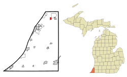
 Location of Coloma, Michigan |
|
| Coordinates: 42°11′12″N 86°18′28″W / 42.18667°N 86.30778°W | |
| Country | United States |
| State | Michigan |
| County | Berrien |
| Area | |
| • Total | 0.89 sq mi (2.31 km2) |
| • Land | 0.89 sq mi (2.31 km2) |
| • Water | 0 sq mi (0 km2) |
| Elevation | 669 ft (204 m) |
| Population (2010) | |
| • Total | 1,483 |
| • Estimate (2012) | 1,475 |
| • Density | 1,666.3/sq mi (643.4/km2) |
| Time zone | Eastern (EST) (UTC-5) |
| • Summer (DST) | EDT (UTC-4) |
| ZIP codes | 911191-49038 |
| Area code(s) | 269 |
| FIPS code | 26-17320 |
| GNIS feature ID | 0623623 |
| Website | City of Coloma, Michigan |
Coloma is a city in Berrien County in the U.S. state of Michigan. The population was 1,483 at the 2010 census.
Coloma was first known as Shingle Diggins because of the wood shingles that were manufactured in the area. The community was renamed Dickerville because people in the town had to barter and dicker for items after the timber supply was exhausted.
The name Coloma was later suggested by Stephen R. Gilson, after a town in California he had visited during the Gold Rush era.
It was incorporated as a village in 1893 and as a city in 1941.
According to the United States Census Bureau, the city has a total area of 0.89 square miles (2.31 km2), all land.
Rich farmland in the area made temperate by Lake Michigan is called the Fruit Belt, and Coloma is located in the Lake Michigan Shore American Viticultural Area.
Coloma is near the former resort area of Paw Paw Lake.
As of the census of 2010, there were 1,483 people, 606 households, and 398 families residing in the city. The population density was 1,666.3 inhabitants per square mile (643.4/km2). There were 667 housing units at an average density of 749.4 per square mile (289.3/km2). The racial makeup of the city was 93.5% White, 1.2% African American, 0.5% Native American, 1.1% Asian, 1.7% from other races, and 2.1% from two or more races. Hispanic or Latino of any race were 3.9% of the population.
...
Wikipedia
