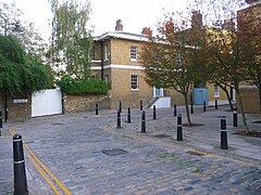
Coldharbour, Tower Hamlets
| Coldharbour | |
|---|---|
 Isle House at the northern end of Coldharbour |
|
|
Coldharbour shown within Greater London
|
|
| OS grid reference | TQ383908 |
| London borough | |
| Ceremonial county | Greater London |
| Region | |
| Country | England |
| Sovereign state | United Kingdom |
| Post town | LONDON |
| Postcode district | E14 |
| Dialling code | 020 |
| Police | Metropolitan |
| Fire | London |
| Ambulance | London |
| EU Parliament | London |
| UK Parliament | |
| London Assembly | |
Coldharbour is a conservation area of Blackwall on the Isle of Dogs in Greater London, England, lying on the north bank of the River Thames, east of Canary Wharf. The area is said to be "[t]he sole remaining fragment of the old hamlet of Blackwall" and "one of the last examples of the narrow streets which once characterised the river's perimeter".
The placename Coldharbour came in use from the early seventeenth century and its origins have been debated since the 1850s. Conflicting etymologies are given by authorities, with Ernest Weekley contending that "[t]his name is very frequently, and very unnecessarily, discussed. Its origin is quite well known, and it means what it appears to mean."
Those accepting the plainest derivation argue that a cold harbour was a "shelter of bare walls... used by travellers who carried their own bedding and provisions", often along a well-known route and similar to a modern bothy.
In alternative, a "coldharbour" could indicate ancient boundary marks in the form of artificial mounds of earth from Roman times, often filled with crockery or charcoal. The word could be derived either from the Latin collis arborum, meaning "hill with trees", or from the Anglo-Saxon col, meaning "coal" or "charcoal", har, "hoary" or "ancient", and bearth, a mound. The link with Roman roads has been contested on the basis that the proximity of Roman roads provides a statistically weak explanation and the fact that the name is not recorded before 1590.
It has also been suggested that most Coldharbour sites could have been named in a mocking manner after a dilapidated London aristocratic house. Other interpretations include "a place where goods were once... assembled for inland water transport or for portage."
Coldharbour was originally a path on the top of the late Mediaeval embankment of the Thames connecting Blackwall Stairs to "somewhere near the present entrance to the south dock of the West India Docks".
The first buildings on Coldharbour appeared by the second decade of the seventeenth century, probably as part of the activities spreading on the Thames riverfront after the opening of the East India Company's shipbuilding yard at Blackwall in 1614. A "ribbon of development" alongside the river at Coldharbour is marked on Joel Gascoyne's map of the Parish of St Dunstan's of 1703, comprising "dwelling houses, public houses, storehouses and warehouses ... interspersed with wharves, yards and even gardens."
...
Wikipedia

