Isle of Dogs
| Isle of Dogs | |
|---|---|
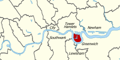
 Location of the Isle of Dogs within Central London |
|
| Isle of Dogs shown within Greater London | |
| OS grid reference | TQ375785 |
| London borough | |
| Ceremonial county | Greater London |
| Region | |
| Country | England |
| Sovereign state | United Kingdom |
| Post town | LONDON |
| Postcode district | E14 |
| Dialling code | 020 |
| Police | Metropolitan |
| Fire | London |
| Ambulance | London |
| EU Parliament | London |
| UK Parliament | |
| London Assembly | |
The Isle of Dogs is an area in the East End of London that is bounded on three sides (east, south and west) by one of the largest meanders in the River Thames. The northern boundary has never been clearly or consistently defined (the name Isle of Dogs had no official status until 1987, with the creation of the Isle of Dogs Neighbourhood by Tower Hamlets Borough Council), but many accept it to be the (former) line of the West India South Dock.
The soil is alluvial and silty in nature, underlaid by clay or mud, with a peat layer in places.
The first known written mention of the Isle of Dogs is in the ‘Letters & Papers of Henry VIII’. In Volume 3: 1519-1523. 2 October 1520. No. 1009 – ‘Shipping’, there is a list of purchases, which includes:
A hose for the Mary George, in dock at the Isle of Dogs, 10d
Brewer's 1898 Dictionary of Phrase and Fable attributes the name: "So called from being the receptacle of the greyhounds of Edward III. Some say it is a corruption of the Isle of Ducks, and that it is so called in ancient records from the number of wild fowl inhabiting the marshes." Other sources discount this, believing these stories to all derive from the antiquarian John Strype, and believe it might come from one of the following:
The whole area was once simply known as Stepney Marsh; Van den Wyngaede's "Panorama of London" dated 1543 depicts and refers to the Isle of Dogs. Records show that ships preparing to carry the English royal household to Calais in 1520 docked at the southern bank of the Island. The name Isle of Dogges occurs in the Thamesis Descriptio of 1588, applied to a small island in the south-western part of the peninsula. The name is next applied to the Isle of Dogs Fam (originally known as Pomfret Manor) shown on a map of 1683. At the same time, the area was variously known as Isle of Dogs or the Blackwell levels. By 1855, it was incorporated within the parish of Poplar under the aegis of the Poplar Board of Works. This was incorporated into the Metropolitan Borough of Poplar on its formation in 1900.
After the building of the Docks (especially the West India Docks and the adjacent City Canal), and with an increasing population, locals increasingly referred to the area as The Island. This area includes Millwall, Cubitt Town, and Blackwall. The south of the isle opposite Greenwich was once known as North Greenwich, now applied to the area around the Millennium Dome on the Greenwich Peninsula. Between 1986 and 1992 it enjoyed a brief formal existence, as the name Isle of Dogs was applied to one of seven neighbourhoods to which power was devolved from the council. The neighbourhood was later abolished.
...
Wikipedia

