Col de Peyresourde
| Col de Peyresourde | |
|---|---|

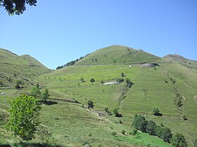
The eastern approach to the Col de Peyresourde
|
|
| Elevation | 1,569 m (5,148 ft) |
| Traversed by | D618 |
| Location | Haute-Garonne/Hautes-Pyrénées, France |
| Range | Pyrenees |
| Coordinates | 42°48′08″N 0°27′46″E / 42.80222°N 0.46278°ECoordinates: 42°48′08″N 0°27′46″E / 42.80222°N 0.46278°E |
|
Location of Col de Peyresourde
|
|
The Col de Peyresourde (Occitan: Còth de Pèira Sorda) (elevation 1,569 m (5,148 ft)) is a mountain pass in the central Pyrenees on the border of the department of Haute-Garonne and Hautes-Pyrénées in France. It is situated on the D618 road between Bagnères-de-Luchon and Arreau.
Starting from Bagnères-de-Luchon (east), the Col de Peyresourde is 15.3 km (9.5 mi) long. Over this distance, the climb is 939 m (3,081 ft) (an average gradient of 6.1%). The steepest sections are 9.8%. No mountain pass cycling milestones for cyclists are placed on this side of the climb. Only close to Bagnères-de-Luchon and 3 kilometres from the summit signposts inform about the overall climb.
Starting from Armenteule (west), the climb is 8.3 km (5.2 mi) long. Over this distance, the climb is 629 m (2,064 ft) (an average gradient of 7.6%). On this side mountain pass cycling milestones for cyclists are placed every kilometre. They indicate the current height, the distance to the summit, and the average slope in the following passage.
View on the last two kilometres in the climb from Armenteule
One of the mountain pass cycling milestones at the climb from Armenteule
Sign at the summit showing that the pass is on the border of the department of Haute-Garonne and Hautes-Pyrénées
The Col de Peyresourde was first used in the Tour de France in 1910 and has appeared frequently since. The leader over the summit in 1910 was Octave Lapize.
...
Wikipedia

