Coire an t-Sneachda
| Coire an t-Sneachda | |
|---|---|

Coire an t-Sneachda
|
|
| Highest point | |
| Coordinates | 57°06′48″N 3°39′50″W / 57.1132°N 3.6640°WCoordinates: 57°06′48″N 3°39′50″W / 57.1132°N 3.6640°W |
| Naming | |
| Translation | Corrie of the snow (Gaelic) |
| Pronunciation | Scottish Gaelic: [ˈkʰɔɾʲ ən̪ˠ ˈt̪ɾɛ̃xkə] |
| Geography | |
| Location |
Inverness-shire, |
| Parent range | Grampian Mountains |
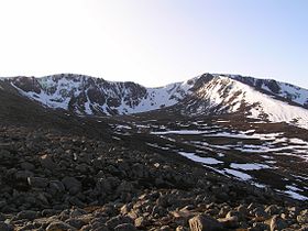
Coire an t-Sneachda (sometimes misspelled as Coire an t'Sneachda) is a glacial cirque or corrie landform in the Cairngorm or Am Monadh Ruadh mountain range in the Grampian Mountains of the Scottish Highlands.
The summits of Cairn Lochan (1215m) and Stob Coire an t-Sneachda (1176m) lie above Coire an t-Sneachda's headwall.
The Gaelic Coire an t-Sneachda roughly translates to the English language as "Corrie of the Snow".
Coire an t-Sneachda is located in Invernesshire, Northern Scotland. The nearest major town is Aviemore. The nearest road access point is the Cairn Gorm ski centre, which is located approximately 4 kilometres (2.5 mi) away (approx. 45–60 minutes walking, in fair conditions).
The country rock is the Caledonian granite of the Cairngorm batholith which gives rise to the high plateau from which the corrie was eroded. The last glacier occupied this corrie or cirque approximately 10,000 to 11,000 years before present during the Younger Dryas stadial. This cold period, which is also known as the Loch Lomond stadial, was the last mini ice-age that brought glaciers and tundra conditions to the Scottish Highlands.
The corrie is home to a number of bird species, including ring ouzel and snow bunting (in the spring and summer) and ptarmigan (also known as rock ptarmigan) (all year round).
The corrie is a popular destination for climbers, primarily because of its easy accessibility from the Cairn Gorm ski centre and the relatively reliable snow and ice conditions throughout the winter season.
...
Wikipedia
