Cairn Gorm
| Cairn Gorm | |
|---|---|

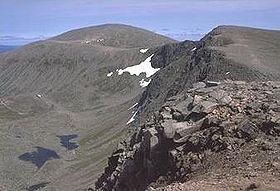
Cairn Gorm from across Coire an t-Sneachda
|
|
| Highest point | |
| Elevation | 1,245 m (4,085 ft) |
| Prominence | 145 m (476 ft) |
| Parent peak | Ben Macdui |
| Listing | Munro |
| Naming | |
| Translation | Blue or Green cairn (Gaelic) |
| Pronunciation | Scottish Gaelic: [əŋ ˈkʰaːrˠŋ ˈkɔɾɔm] |
| Geography | |
| Location | Cairngorms, Scotland |
| OS grid | NJ005040 |
| Topo map | OS Landranger 36 |
| Climbing | |
| Easiest route | Hike |
| Listed summits of Cairn Gorm | ||||
| Name | Grid ref | Height | Status | |
|---|---|---|---|---|
| Cairn Lochan | NH985025 | 1215 | Munro Top | |
| Stob Coire an t-Sneachda | NH996029 | 1176 | Munro Top | |
| Cnap Coire na Spreidhe | NJ013049 | 1150 | Munro Top | |
| Creag an Leth-choin | NH968033 | 1053 | Munro Top | |
| Cairngorm Mountain | |
|---|---|

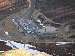
Cairngorm Mountain base station in early 2008
|
|
| Location |
Carn Gorm, Aviemore Highland, Scotland United Kingdom |
| Nearest city | Inverness - 40 mi. (65 km) |
| Vertical | 500 m |
| Top elevation | 1145 m |
| Base elevation | 645 m Base Station |
| Runs | 35 |
| Lift system | 14 - 1 railway (120 person) - 2 doubles (mothballed) - 11 surface |
| Snowmaking | 4 TechnoAlpin T40, 1 TechnoAlpin TF10 |
| Night skiing | occasional |
| Website | CairnGorm Mountain |
Cairn Gorm (Cairngorm) (Gaelic: An Càrn Gorm, meaning Blue or Green Hill) is a mountain in the Scottish Highlands overlooking Strathspey and the town of Aviemore. At 1245 metres (4084 ft) it is the sixth-highest mountain in the United Kingdom. It has given its name to the whole range, although these hills were historically known as Am Monadh Ruadh (the Red Hills) rather than the Cairngorms. Cairn Gorm is the most prominent of the Cairngorm mountains in the view from Aviemore, but it is not the highest.
600 ha of the north-western slopes of the mountain have been developed since 1960 for downhill skiing, in Coire Cas and Coire na Ciste. In 2001 a funicular railway was constructed to provide access through Coire Cas to the Ptarmigan building at 1087m on Cairn Gorm.
The corrie south of Coire Cas, Coire an t-Sneachda, is separated from the skiing area by a ridge known as Fiacaill a' Choire Chais. The southern side of Cairn Gorm overlooks the remote loch known as Loch Avon (pronounced Loch A'an).
There is an automated weather station (AWS) controlled by Heriot-Watt University on the summit of the mountain providing temperature and wind speed data. There is also a separate AWS run by the Met Office (synop code 03065).
The ascent of Cairn Gorm is technically straightforward via the Northern slopes, but weather conditions can make it impossible during high winds and falling or blowing snow (often referred to as blizzard conditions). The Windy Ridge path on Sròn an Aonaich lying to the northeast of Coire Cas is a steep and direct route, and is generally recommended by local Rangers, guides and guidebooks. Another route to the summit is the access road up the centre of Coire Cas, however this route is a track used by the railway operator's vehicles, and gives an indirect route with several steep sections. It is not recommended as an ascent route, especially during the skiing season, though it gives good views of the Cairngorm Mountain Railway in its lower sections. Also in Coire Cas, Fiacaill a' Choire Chais offers a good walking route to Cairn Gorm and the adjacent plateau. A circuit of the cliff tops overlooking the Northern Corries of Cairn Gorm is highly recommended in many guide books and publications, giving one of the finest views in Scotland. Walkers are advised to consult the local map and call in at the Ranger Base at the car park.
...
Wikipedia
