Cocos (Keeling) Islands Airport
|
Cocos (Keeling) Island Airport Lapangan Terbang Pulu Koko |
|||||||||||
|---|---|---|---|---|---|---|---|---|---|---|---|

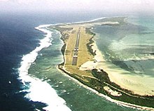
Aerial view in the direction of Runway 33
|
|||||||||||
| Summary | |||||||||||
| Airport type | Public | ||||||||||
| Operator | Toll Remote Logistics | ||||||||||
| Location | West Island, Cocos (Keeling) Islands | ||||||||||
| Elevation AMSL | 10 ft / 3 m | ||||||||||
| Coordinates | 12°11′19″S 096°49′50″E / 12.18861°S 96.83056°ECoordinates: 12°11′19″S 096°49′50″E / 12.18861°S 96.83056°E | ||||||||||
| Map | |||||||||||
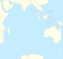
| Location on a map of the Indian Ocean | |||||||||||
| Runways | |||||||||||
|
|||||||||||
| Statistics (2010/11) | |||||||||||
|
|||||||||||
| Passengers | 15,712 |
|---|---|
| Aircraft movements | 303 |
Cocos (Keeling) Island Airport (IATA: CCK, ICAO: YPCC) is an airport serving the Cocos (Keeling) Islands, a territory of Australia located in the Indian Ocean. The airport is located on West Island, one of the South Keeling Islands and capital of the territory.
The airfield was built during World War II to support Allied aircraft in the war against Japan.
The airport has one runway, designated 15/33, with an asphalt surface measuring 2,441 m × 45 m (8,009 ft × 148 ft) and an elevation of 10 ft (3 m) above sea level.
Cocos Island Airport is not one of the busiest in Australia but still served 15,712 revenue passengers during financial year 2010–2011.
...
Wikipedia

