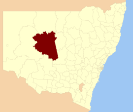
Cobar Shire
|
Cobar Shire New South Wales |
|||||||||||||
|---|---|---|---|---|---|---|---|---|---|---|---|---|---|

Location in New South Wales
|
|||||||||||||
| Coordinates | 31°29′S 145°48′E / 31.483°S 145.800°ECoordinates: 31°29′S 145°48′E / 31.483°S 145.800°E | ||||||||||||
| Population | 4,975 (2015 est) | ||||||||||||
| • Density | 0.11/km2 (0.28/sq mi) | ||||||||||||
| Area | 44,065 km2 (17,013.6 sq mi) | ||||||||||||
| Mayor | Lilliane Brady (Unaligned) | ||||||||||||
| Council seat | Cobar | ||||||||||||
| Region | Orana | ||||||||||||
| State electorate(s) | Barwon | ||||||||||||
| Federal Division(s) | Parkes | ||||||||||||
 |
|||||||||||||
| Website | Cobar Shire | ||||||||||||
|
|||||||||||||
Cobar Shire is a local government area in the Orana region of New South Wales, Australia. The Shire is located in an outback area that is based on the mining town of Cobar. The Shire is traversed by the Barrier Highway and the Kidman Way. With a total area of 44,065 square kilometres (17,014 sq mi), about two- thirds the size of Tasmania. Cobar Shire is larger than Denmark and 99 other countries and self-governing territories.
The Mayor of Cobar Shire Council is Cr. Lilliane Brady, who is unaligned with any political party.
The shire also includes four very small outback towns; the twin villages of Euabalong and Euabalong West in the far south east of the shire, Mount Hope, and Nymagee.
According to the Australian Bureau of Statistics during 2003-04 there:
Cobar Shire Council is composed of twelve Councillors elected proportionally as a single ward. All Councillors are elected for a fixed four-year term of office. The Mayor is elected by the Councillors at the first meeting of the Council. The most recent election was held on 10 September 2016. However, only twelve candidates, being those below, nominated for election. There being no additional candidates, the election was uncontested. The makeup of the Council is as follows:
...
Wikipedia
