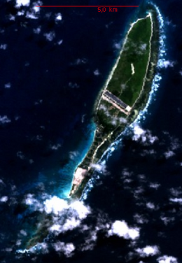
Coëtivy Island

Coëtivy Island. NASA Image
|
|
| Geography | |
|---|---|
| Location | Indian Ocean |
| Coordinates | 07°08′S 56°16′E / 7.133°S 56.267°ECoordinates: 07°08′S 56°16′E / 7.133°S 56.267°E |
| Archipelago | Seychelles |
| Adjacent bodies of water | Indian Ocean |
| Total islands | 1 |
| Major islands |
|
| Area | 9.33 km2 (3.60 sq mi) |
| Length | 9.5 km (5.9 mi) |
| Width | 1.5 km (0.93 mi) |
| Coastline | 20.4 km (12.68 mi) |
| Highest elevation | 21 m (69 ft) |
| Administration | |
| Group | Outer Islands |
| Sub-Group | Southern Coral Group |
| Districts | Outer Islands District |
| Largest settlement | Coëtivy (pop. 260) |
| Demographics | |
| Population | 260 (2014) |
| Pop. density | 27.9 /km2 (72.3 /sq mi) |
| Ethnic groups | Creole, French, East Africans, Indians. |
| Additional information | |
| Time zone | |
| ISO code | SC-26 |
| Official website | www |
Coëtivy Island is a small coral island in the Seychelles 290 km (180 mi) south of Mahé, at 07°08′S 56°16′E / 7.133°S 56.267°E.
Along with Île Platte, the nearest neighbor 171 km (106 mi) northwest, it comprises the Southern Coral Group and therefore belongs to the Outer Islands.
It was named after Chevalier de Coëtivy, commander of the Ile de France who first sighted the island in 1771. In 1908 it was transferred from Mauritius to Seychelles. In 1970 the island was purchased by the parastatal Seychelles Marketing Board (SMB). In 1989, SMB began producing shrimp. Coëtivy Island became famous for its shrimp farms (black tiger prawn) and shrimp processing plant that operated on the island. Large scale production began on August 1992. However, in 1998, due to hard financial times, the plant closed. in 2009, the island became the site of an active prison (Ministry of Internal Affairs choice) for low security prisoners and a rehabilitation center for drug abusers. Visitation is strictly controlled and access is only possible by private airplane charter. by 2020, the Prison should be increased to capacity of 600 inmates. by 2020, the island is expected to have more residential apartments
The island has an area of 9.33 km2 (3.60 sq mi), is low and heavily wooded.
...
Wikipedia

