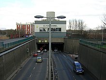
Clyde Tunnel

The south portal of the Clyde Tunnel at Linthouse
|
|
| Overview | |
|---|---|
| Official name | Clyde Tunnel |
| Location | River Clyde, Linthouse and Whiteinch in Glasgow |
| Coordinates | 55°52′07″N 4°19′52″W / 55.86867°N 4.33115°WCoordinates: 55°52′07″N 4°19′52″W / 55.86867°N 4.33115°W |
| Route | A739 road |
| Operation | |
| Opened | 3 July 1963 |
| Operator | Glasgow City Council |
| Traffic | 65,000 |
| Toll | Free |
| Technical | |
| Design engineer | Sir Alan Muir Wood of Halcrow |
| Length | 762 metres (2,500.0 ft) (northbound and southbound) |
| No. of lanes | 4 |
| Tunnel clearance | 17.5 feet (5.3 m) |
The Clyde Tunnel is a crossing beneath the River Clyde in Glasgow, Scotland. Two parallel tunnel tubes connect the districts of Whiteinch to the north and Govan to the south in the west of the city.
Efforts to improve the transport infrastructure of Glasgow post-World War II were hit by the problem of crossing the Clyde. Downstream of Jamaica Street in the city centre, it was perceived to be impossible to build a bridge due to the prevalence of shipping in what had been the second city of the British Empire still reliant on the sea. The solution — to build a tunnel beneath the river — was not a new one, with the Harbour Tunnel at Finnieston having been built in the 1890s. However, the Clyde Tunnel project was to be built in the boom of the car era and would be a much larger project. It was given the green light in 1948 but financial difficulties prevented work from beginning until 1957.
A tunnelling shield, based on Marc Isambard Brunel's design used for the Thames Tunnel a century earlier, was used to dig the two tunnels. The tunnels were cut perfectly circular with the road deck sitting a third of the way up. Under each road deck is the pedestrian/cycle tunnel and ventilation ducts. 16 miners operated the shield working shifts in a compressed air environment to ensure that the rock and the river above did not collapse into the tunneling area. The digging itself would be done only with great difficulty due to the geology of the area, hard rock sitting under a soft silt layer beneath the river.
...
Wikipedia
