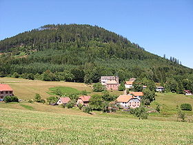
Climont
| Climont | |
|---|---|
| Weinberg (in Alsatian) | |

Climont, hamlet and peak
|
|
| Highest point | |
| Elevation | 965 m (3,166 ft) |
| Coordinates | 48°20′45″N 007°11′06″E / 48.34583°N 7.18500°ECoordinates: 48°20′45″N 007°11′06″E / 48.34583°N 7.18500°E |
| Geography | |
| Location | France |
| Parent range | Vosges |
Climont, formerly called "Clivemont" in Old French, and "Winberg" in Old Alsatian, is a conical sandstone peak of the Vosges mountains. The mountain, with a cut-off shape, is known from afar by walkers and modern-day travellers.
Situated today in Alsace to the south-west of the Champ du Feu, Clivemont's 965 metre peak is recognizable from a distance by its trapezoidal shape. The solitary tomb-shaped hill has long been a landmark to the south of the straight voie des saulniers (a salt trading route), at the start of the massif running from Ormont.
Climont offers an exceptional panorama of the various surrounding valleys. The waterways which originate there include the Fave river in the south-west which flows into the Meurthe above Saint-Dié, the Bruche river and several streams such as the winding Climontaise, which flow into Bourg-Bruche and Schirmeck to the north and finally the Giessen river to the south-east which flows towards Urbeis. The 360° view reveals Donon and the Val de Bruche to the north, the Val de Villé to the east, the middle Vosges to the south, and the Saint-Dié basin to the west.
The mountains, which beyond 650 or 700 metres up belong to the territory of the Urbeis commune, are highly prized by hill-walkers. The GR532 walking route passes by the south, and two routes marked by the Vosges Club (Club Vosgien) lead to the summit where a tower stands in memory of Julius Euting, commonly referred to as the "Tour Jules".
Climont has given pleasure to travellers from Lorraine on the Saulniers way, announcing the proximity of the Ungersberg massif and its hills overlooking the Alsatian plain. It is also a useful landmark for mountain-dwellers; its wide-ranging views of over the Saint-Dié basin allow humidity testing of air layers, and wind forecasting in case of unusual wind patterns such as the coldest winter breezes or east winds coming down from the mountains. The cone of Climont is easily identifiable from the Roche Saint-Martin and from the heights of Hadremont north or east of the Kemberg massif, byt also at different height to the south of the Fave valley. Today drivers who take the fast route passing around Saint-Dié or entering the Fave valley in the direction of the Lusse tunnel or the Saales col can contemplate the splendid isolation and magnificent evening lighting of Climont's slopes.
...
Wikipedia
