Clew Bay
| Clew Bay | |
|---|---|

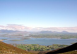
Overlooking Murrisk and Clew Bay
|
|
 |
|
| Location | County Mayo. |
| Coordinates | 53°50′N 9°48′W / 53.833°N 9.800°WCoordinates: 53°50′N 9°48′W / 53.833°N 9.800°W |
| Ocean/sea sources | Atlantic Ocean. |
| Basin countries | Ireland |
| Settlements | Louisburgh, Lecanvey, Murrisk, Westport, Newport, Mulranny |
Clew Bay (Irish: Cuan Mó) is a natural ocean bay in County Mayo, Republic of Ireland. It contains Ireland's best example of sunken drumlins. The bay is overlooked by Croagh Patrick to the south and the Nephin Range mountains of North Mayo. Clare Island guards the entrance of the bay. From the southwest part of the bay eastwards are Louisburgh, Lecanvey, Murrisk, and Westport; north of Westport is Newport, and westwards from there lies Mulranny, gateway to Achill. From the south side of the bay, between Clare Island and Achill, Bills Rocks can be seen.
Clew Bay was the focus of the O'Malley family possessions in the Middle Ages, and is associated especially with Grace O'Malley or Granuaile. She is known as the Pirate Queen who commanded a fleet of ships and maintained several castles, including those on Clare Island, Achill and Rockfleet.
During the Irish Civil War in July 1922, 400 Free State troops were landed at Clew Bay to take Westport and Castlebar from Anti-Treaty forces.
Stands on Inishgort island 5 km from Murrisk.
In recent years there has been controversy over fish-farming in the bay. "The Organic Salmon Company" is based in Clare Island.
Clew Bay as seen from the top of Croagh Patrick.
Clew Bay as seen from the foot of Croagh Patrick.
Memorial for the victims of the Clew Bay Drowning on June 14, 1894 at Kildavenet Graveyard, Achill Island
...
Wikipedia
