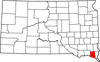
Clay County, South Dakota
| Clay County, South Dakota | |
|---|---|

Clay County Courthouse
|
|
 Location in the U.S. state of South Dakota |
|
 South Dakota's location in the U.S. |
|
| Founded | 1862 |
| Named for | Henry Clay |
| Seat | Vermillion |
| Largest city | Vermillion |
| Area | |
| • Total | 417 sq mi (1,080 km2) |
| • Land | 412 sq mi (1,067 km2) |
| • Water | 5.1 sq mi (13 km2), 1.2% |
| Population (est.) | |
| • (2015) | 13,964 |
| • Density | 34/sq mi (13/km²) |
| Congressional district | At-large |
| Time zone | Central: UTC-6/-5 |
| Website | www |
Clay County is a county located in the U.S. state of South Dakota. As of the 2010 census, the population was 13,864. The county seat is Vermillion, which is also home to the University of South Dakota. The county is named in honor of Henry Clay, American statesman, member of the United States Senate from Kentucky and United States Secretary of State in the 19th century.
Clay County comprises the Vermillion, SD Micropolitan Statistical Area, which is also included in the Sioux City-Vermillion, IA-SD-NE Combined Statistical Area.
Clay County began forming in 1859 when the land was opened for legal occupation. In the fall of that year, Ahira A. Partridge (who would later become the first elected sheriff of the county) crossed the Missouri river into the Dakota territory, and became the first white man to settle what would become Clay county; squatting on 160 acres of land that encompass most of the present-day city of Vermillion. In 1862 the county was formally organized. The Clay County Courthouse was built in 1912.
Clay County is the name of in the United States, most of them named in honor of Henry Clay.
According to the U.S. Census Bureau, the county has a total area of 417 square miles (1,080 km2), of which 412 square miles (1,070 km2) is land and 5.1 square miles (13 km2) (1.2%) is water. It is the smallest county by area in South Dakota.
As of the census of 2000, there were 13,537 people, 4,878 households, and 2,721 families residing in the county. The population density was 33 people per square mile (13/km²). There were 5,438 housing units at an average density of 13 per square mile (5/km²).
...
Wikipedia
