Clay, New York
| Clay, New York | |
|---|---|
| Town | |

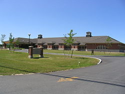
Clay town hall
|
|
 Location in Onondaga County and the state of New York. |
|
| Coordinates: 43°9′2″N 76°11′39″W / 43.15056°N 76.19417°WCoordinates: 43°9′2″N 76°11′39″W / 43.15056°N 76.19417°W | |
| Country | United States |
| State | New York |
| County | Onondaga |
| Government | |
| • Type | Town Council |
| • Town Supervisor | Damian M. Ulatowski (R) |
| • Town Council |
Members' List
|
| Area | |
| • Total | 48.8 sq mi (126.4 km2) |
| • Land | 48.0 sq mi (124.3 km2) |
| • Water | 0.8 sq mi (2.0 km2) |
| Elevation | 377 ft (115 m) |
| Population (2010) | |
| • Total | 58,206 |
| Time zone | Eastern (EST) (UTC-5) |
| • Summer (DST) | EDT (UTC-4) |
| ZIP code | 13041, 13090, 13088 |
| Area code(s) | 315 |
| FIPS code | 36-16067 |
| GNIS feature ID | 0978835 |
Clay is a town in Onondaga County, New York, United States. As of the 2010 census, the town had a total population of 58,206, making it Syracuse's largest suburb. The town was named after Henry Clay, statesman.
Clay is northwest of Syracuse, New York. It is the largest town in the county, contains part of the village of North Syracuse, and is an affluent suburb of Syracuse. It contains the major retail strip of Syracuse's northwesterly suburbs, along New York State Route 31 (NY-31), including the Great Northern Mall.
Prior to European settlement in the area, Clay was inhabited by the Onondaga Nation, part of the Iroquois Confederacy, some of whose descendants still live in the area today.
Clay was within the Central New York Military Tract. The town was first settled by outsiders around 1791 and was previously known as West Cicero.
The Town of Clay was formed in 1827 from the Town of Cicero, one of the original townships of the military tract.
According to the United States Census Bureau, the town has a total area of 48.8 square miles (126 km2), of which 48.0 square miles (124 km2) is land and 0.8 square miles (2.1 km2) of it (1.60%) is water.
The northern town line is the border of Oswego County, New York, marked by the Oneida River. The Seneca River marks the western town line. Both these rivers join into the Oswego River near the community of Three Rivers. The renovated Erie Canal follows the rivers around the border of Clay.
...
Wikipedia
