Clatsop County
| Clatsop County, Oregon | ||
|---|---|---|

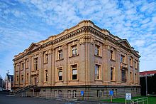
Clatsop County Courthouse in Astoria
|
||
|
||
 Location in the U.S. state of Oregon |
||
 Oregon's location in the U.S. |
||
| Founded | June 22, 1844 | |
| Seat | Astoria | |
| Largest city | Astoria | |
| Area | ||
| • Total | 1,084 sq mi (2,808 km2) | |
| • Land | 829 sq mi (2,147 km2) | |
| • Water | 255 sq mi (660 km2), 24% | |
| Population (est.) | ||
| • (2015) | 37,831 | |
| • Density | 45/sq mi (17/km²) | |
| Congressional district | 1st | |
| Website | www |
|
Clatsop County /ˈklætsəp/ is a county in the U.S. state of Oregon. As of the 2010 census, the population was 37,039. The county seat is Astoria. The county is named for the Clatsop tribe of Native Americans, who lived along the coast of the Pacific Ocean prior to European settlement.
Clatsop County comprises the Astoria, OR Micropolitan Statistical Area and is located in Northwest Oregon.
The Lewis and Clark Expedition stayed for the winter of 1805–6 in the area of the future county at Fort Clatsop. Astoria, Oregon's oldest settlement, was established as a fur trading post in 1811 and named after John Jacob Astor.
Clatsop County was created from the northern and western portions of the original Twality District on June 22, 1844. Until the creation of Vancouver District five days later, Clatsop County extended north across the Columbia into present-day Washington. The Provisional and Territorial Legislatures further altered Clatsop County's boundaries in 1845 and 1853.
...
Wikipedia

