Clarkson, Nebraska
| Clarkson, Nebraska | |
|---|---|
| City | |

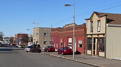
Downtown Clarkson: east side of Pine Street
|
|
 Location of Clarkson, Nebraska |
|
| Coordinates: 41°43′29″N 97°7′23″W / 41.72472°N 97.12306°WCoordinates: 41°43′29″N 97°7′23″W / 41.72472°N 97.12306°W | |
| Country | United States |
| State | Nebraska |
| County | Colfax |
| Area | |
| • Total | 0.79 sq mi (2.05 km2) |
| • Land | 0.79 sq mi (2.05 km2) |
| • Water | 0 sq mi (0 km2) |
| Elevation | 1,496 ft (456 m) |
| Population (2010) | |
| • Total | 658 |
| • Estimate (2012) | 660 |
| • Density | 832.9/sq mi (321.6/km2) |
| Time zone | Central (CST) (UTC-6) |
| • Summer (DST) | CDT (UTC-5) |
| ZIP code | 68629 |
| Area code(s) | 402 |
| FIPS code | 31-09200 |
| GNIS feature ID | 0828161 |
Clarkson is a city in Colfax County, Nebraska, United States. The population was 658 at the 2010 census.
Clarkson was platted in 1886 when it was certain that a new railroad line extended to the site. It was named for T. S. Clarkson, a postal official who helped establish the town's first post office.
Clarkson is located at 41°43′29″N 97°7′23″W / 41.72472°N 97.12306°W (41.724676, -97.123015).
According to the United States Census Bureau, the city has a total area of 0.79 square miles (2.05 km2), all of it land.
Clarkson is located in Northeast Nebraska, three miles west of the junction of Nebraska Highways 15 and 91. Clarkson lies 35 miles southeast of Norfolk, Nebraska; 35 miles northeast of Columbus, Nebraska; 85 miles northwest of Omaha, Nebraska; and 90 miles northwest of Lincoln, Nebraska.
As of the census of 2010, there were 658 people, 285 households, and 168 families residing in the city. The population density was 832.9 inhabitants per square mile (321.6/km2). There were 342 housing units at an average density of 432.9 per square mile (167.1/km2). The racial makeup of the city was 98.3% White, 0.2% Pacific Islander, 0.9% from other races, and 0.6% from two or more races. Hispanic or Latino of any race were 2.6% of the population.
...
Wikipedia
