Clarksburg, Ohio
| Clarksburg, Ohio | |
|---|---|
| Village | |
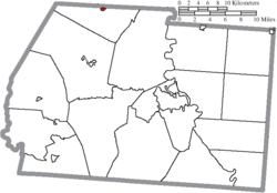
 Location of Clarksburg, Ohio |
|
 Location of Clarksburg in Ross County |
|
| Coordinates: 39°30′23″N 83°9′16″W / 39.50639°N 83.15444°WCoordinates: 39°30′23″N 83°9′16″W / 39.50639°N 83.15444°W | |
| Country | United States |
| State | Ohio |
| County | Ross |
| Area | |
| • Total | 0.17 sq mi (0.44 km2) |
| • Land | 0.17 sq mi (0.44 km2) |
| • Water | 0 sq mi (0 km2) |
| Elevation | 771 ft (235 m) |
| Population (2010) | |
| • Total | 455 |
| • Estimate (2012) | 455 |
| • Density | 2,676.5/sq mi (1,033.4/km2) |
| Time zone | Eastern (EST) (UTC-5) |
| • Summer (DST) | EDT (UTC-4) |
| ZIP code | 43115 |
| Area code(s) | 740 |
| FIPS code | 39-15336 |
| GNIS feature ID | 1060975 |
Clarksburg is a village in Ross County, Ohio, United States. The population was 455 at the 2010 census.
The first permanent settlement at Clarksburg was made c. 1800. Clarksburg was platted in 1817 by George Clark, and named for him.
Clarksburg corporation limit sign.
Intersection of Main and High Streets in Clarksburg.
Along High Street (Ohio Highway 138) in Clarksburg.
Water tower in Clarksburg.
Zurmehly Park.
Zurmehly Park.
Zurmehly Park.
Zurmehly Park.
Zurmehly Park.
Site of former Clarksburg/Deerfield Township High School (1893 - 1965).
Clarksburg is located at 39°30′23″N 83°9′16″W / 39.50639°N 83.15444°W (39.506388, -83.154524).
According to the United States Census Bureau, the village has a total area of 0.17 square miles (0.44 km2), all land.
As of the census of 2010, there were 455 people, 166 households, and 117 families residing in the village. The population density was 2,676.5 inhabitants per square mile (1,033.4/km2). There were 184 housing units at an average density of 1,082.4 per square mile (417.9/km2). The racial makeup of the village was 98.5% White, 0.2% African American, 0.4% from other races, and 0.9% from two or more races. Hispanic or Latino of any race were 1.8% of the population.
...
Wikipedia
