Clarksburg, Maryland
| Clarksburg, Maryland | ||
|---|---|---|
| census-designated place | ||

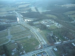
An aerial view of Clarksburg, Maryland in January 2007.
|
||
|
||
 Location of Clarksburg, Maryland |
||
| Coordinates: 39°13′10″N 77°17′17″W / 39.21944°N 77.28806°WCoordinates: 39°13′10″N 77°17′17″W / 39.21944°N 77.28806°W | ||
| Country | ||
| State |
|
|
| County |
|
|
| Founded | 1752 | |
| Area | ||
| • Total | 8.3 sq mi (21.3 km2) | |
| • Land | 8.2 sq mi (21.2 km2) | |
| • Water | 0.1 sq mi (0.1 km2) | |
| Elevation | 663 ft (202 m) | |
| Population (2010) | ||
| • Total | 13,677 | |
| • Density | 4,319.9/sq mi (1,667.9/km2) | |
| Time zone | Eastern (EST) (UTC-5) | |
| • Summer (DST) | EDT (UTC-4) | |
| ZIP code | 20871 | |
| Area code(s) | 301 | |
| FIPS code | 24-17350 | |
| GNIS feature ID | 0583799 | |
Clarksburg is a census-designated place and an unincorporated area in northern Montgomery County, Maryland, United States, located along the Interstate 270 technology corridor about 4 miles north of Germantown, MD. As of Census 2010 its population was 13,766.
As an unincorporated area, Clarksburg's boundaries are not officially defined. Clarksburg is, however, recognized by the United States Census Bureau as a census-designated place, and by the United States Geological Survey as a populated place.
According to the United States Census Bureau, it has a total area of 8.3 square miles (21 km2), of which, 8.2 square miles (21 km2) of it is land and 0.1 square miles (0.26 km2) of it (1.82%) is water.
As of the 2010 census, there were 13,766 people and 4,352 households residing in the area. The population density was 1,667.9 people per square mile (51.2/km²). The population is roughly 44.1% White, 14.7% African-American, 0.1% American Indian or Alaska Native, 33.6% Asian, 0.1% Native Hawaiian or Pacific Islander, including 9.8% of the population Hispanic or Latino origin of any race.
In 2000 there were 604 households, out of which 42.1% had children under the age of 18 living with them, 72.0% were married couples living together, 6.6% had a female householder with no husband present, and 17.5% were non-families. 13.9% of all households were made up of individuals and 4.6% had someone living alone who was 65 years of age or older. The average household size was 3.04 and the average family size was 3.34.
In the area, the population was spread out with 29.3% under the age of 18, 4.8% from 18 to 24, 29.7% from 25 to 44, 27.4% from 45 to 64, and 8.8% who were 65 years of age or older. The median age was 38 years. For every 100 females there were 100.2 males. For every 100 females age 18 and over, there were 103.6 males.
...
Wikipedia

