Civic Center station (Metrorail)
| Metrorail metro station | |||||||||||||||

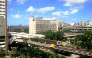
View from the UM/Jackson medical complex and Metrorail train entering the station
|
|||||||||||||||
| Location | 1501 NW 12th Avenue, Miami, Florida 33136 |
||||||||||||||
| Coordinates | 25°47′23″N 80°12′54″W / 25.78972°N 80.21500°WCoordinates: 25°47′23″N 80°12′54″W / 25.78972°N 80.21500°W | ||||||||||||||
| Owned by | Miami-Dade County | ||||||||||||||
| Line(s) | |||||||||||||||
| Platforms | 2 side platforms | ||||||||||||||
| Tracks | 2 | ||||||||||||||
| Connections |
|
||||||||||||||
| Construction | |||||||||||||||
| Disabled access | Yes | ||||||||||||||
| Other information | |||||||||||||||
| Station code | CVC | ||||||||||||||
| History | |||||||||||||||
| Opened | December 17, 1984 | ||||||||||||||
| Traffic | |||||||||||||||
| Passengers (2011) | 1.7 million |
||||||||||||||
| Services | |||||||||||||||
|
|||||||||||||||
Civic Center station is a station on the Metrorail rapid transit system in Miami, Florida's Health District, which is also known as Civic Center. The station is located at the intersection of Northwest 12th Avenue (State Road 933) and 15th Street, opening to service December 17, 1984. Civic Center provides a convenient connection for University of Miami medical students by connecting the hospital area to the main campus at University station.
...
Wikipedia
