City of Hurstville
|
City of Hurstville New South Wales |
|
|---|---|

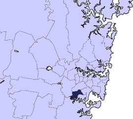
Location in Metropolitan Sydney
|
|
| Coordinates | 33°58′S 151°06′E / 33.967°S 151.100°ECoordinates: 33°58′S 151°06′E / 33.967°S 151.100°E |
| Population | 80,823 (2011 census) |
| • Density | 3,510/km2 (9,100/sq mi) |
| Established | 1988 |
| Abolished | 2016 |
| Area | 23 km2 (8.9 sq mi) |
| Website | City of Hurstville |
The City of Hurstville was a local government area in the St George and southern region of Sydney, New South Wales, Australia. The city centre of Hurstville is located 17 kilometres (11 mi) south–west of Sydney and west of Botany Bay.
Hurstville was incorporated as a municipality in 1887; and declared a city in 1988; and abolished in 2016.
A 2015 review of local government boundaries by the NSW Government Independent Pricing and Regulatory Tribunal recommended that the City of Hurstville merge with the City of Kogarah to form a new council with an area of 38 square kilometres (15 sq mi) and support a population of approximately 147,000. On 12 May 2016 the NSW Government announced that the City of Hurstville would merge with the neighbouring City of Kogarah to establish the Georges River Council, with immediate effect.
Suburbs in the City of Hurstville were:
Hurstville City Council also managed and maintained the following localities:
At the 2011 Census, there were 78,855 people in the Hurstville local government area, of these 48.5% were male and 51.5% were female. Aboriginal and Torres Strait Islander people made up 0.6% of the population. The median age of people in the City of Hurstville was 37 years. Children aged 0 – 14 years made up 17.7% of the population and people aged 65 years and over made up 15.4% of the population. Of people in the area aged 15 years and over, 53.4% were married and 9.2% were either divorced or separated.
...
Wikipedia
