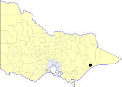
City of Bairnsdale
|
City of Bairnsdale Victoria |
|
|---|---|

Location in Victoria
|
|
| Population | 11,270 (1992) |
| • Density | 414.34/km2 (1,073.1/sq mi) |
| Established | 1967 |
| Area | 27.20 km2 (10.5 sq mi) |
| Council seat | Bairnsdale |
| County | Dargo |
The City of Bairnsdale was a local government area about 280 kilometres (174 mi) east of Melbourne, the state capital of Victoria, Australia. The City covered an area of 27.20 square kilometres (10.5 sq mi), and existed from its split from the Shire of Bairnsdale in 1967 until 1994.
Originally inhabited by the Kurnai Aborigines, the area was explored by Angus McMillan in 1840. It was McMillan who named the Mitchell River on which the nearby land the township stands. Two years later Frederick Jones became the first European settler in the area when he settled at what is now known as Lucknow, using the land to breed horses for the Indian market.
Archibald MacLeod was the first settler to take up land in the area now covered by the present town. He called his run "Bernisdale" after his birthplace on the Isle of Skye. Legend has it that the name was changed to its present spelling when MacLeod was surprised by the number of "bairns" ("children" in the Scots language) which had appeared in the settlement. However, it seems more likely that the spelling was merely altered to fit local pronunciation. In the 1850s and 1860s the town grew as a result of its location on the Mitchell River and its access to the sea. It became a supply port for the East Gippsland goldfields until the railways were established later in the century. Goods were shipped into Lake King, up the Mitchell River to Bairnsdale then hauled overland, often by bullock teams. Ships were then loaded with cattle products and wool from the surrounding area for the return trip to Melbourne. The hops cultivated in the Mitchell Valley between 1868 and 1916 were also transported to Bairnsdale for shipment to the hop kilns. Some of the Hop Kilns still remain till this day on the eastern side of the Mitchell River. A bridge over the Mitchell River was commenced in 1870 and completed in 1875. A lift bridge was originally envisaged so that ships could continue along the Mitchell River to the original wharf near The Butter Factory.
A post office was set up in 1856 and the township was surveyed and gazetted the following decade. A police station was established in 1862, a courthouse, school and post office were built six years later and the railway arrived in 1888. Barges conveyed wattle bark down the river to Jackson's tannery which commenced operations in 1876. A factory producing mining tools was opened the following year, an ice and butter plant in 1891, and a fruit cannery in 1907. Attempts were also made to develop an oil seed industry between 1890 and 1910.
...
Wikipedia
