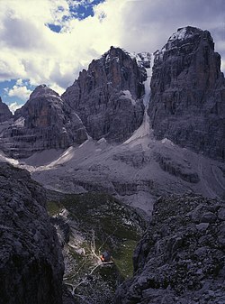
Cima Tosa
| Cima Tosa | |
|---|---|

Cima Tosa and Crozzon di Brenta
|
|
| Highest point | |
| Elevation | 3,173 m (10,410 ft) IGM |
| Prominence | 1,521 m (4,990 ft) |
| Listing | Ultra |
| Coordinates | 46°09′20″N 10°52′19″E / 46.15556°N 10.87194°E |
| Geography | |
| Location | Trentino-Alto Adige/Südtirol, Italy |
| Parent range | Brenta group, Rhaetian Alps |
| Climbing | |
| First ascent | 18-07-1865 |
| Easiest route | Via Normale |
Cima Tosa is a mountain in the Brenta group (It.: Dolomiti di Brenta), a subgroup of the Rhaetian Alps in the Italian Region of Trentino-Alto Adige, with a reported height of 3,173 metres (10,410 ft). With this elevation, the prominence of Cima Tosa would amount up to 1,521 meters above the reference point at Passo Carlo Magno near Madonna di Campiglio at 1,652 meters. Cima Tosa therefore qualifies as one of Europe's ultra prominent peaks. The mountain rises above Val Rendena with its 800-metre (2,600 ft) vertical north face with a steep couloir called Canalone della Tosa dividing it from its ante-peak, Crozzon di Brenta. The summit is topped by a snow cupola above the rock face, almost like a shaven head, hence the name Cima Tosa (Iocal dialect: Shaven Summit). The south-eastern side descends in a series of snowy terraces and vertical rock pillars.
Cima Tosa's reported elevation is 3,173 metres (10,410 ft). With this elevation, it is the Brenta Group's highest point and the 38th alpine ultra-prominent peak. The height of Cima Tosa was determined by triangulation measurement under Austro-Hungarian rule and later in the 1930s. If done correctly, a correction should have been applied that would have deducted the thickness of the snow cover. In the case of Cima Tosa summit, where the snow forms its characteristic snow dome, that layer of snow may have been substantial and difficult to measure. Recent amateur research has suggested that Cima Tosa is not as high as 3,173 meters and might even be lower than Cima Brenta. Due to global warming, the summit snow dome may have shrunk some 20 metres (66 ft) in height, explaining an allegedly consistent GPS-reading of around 3,150 meters on the top of Cima Tosa. Undoubtedly, the snow cap on Cima Tosa has suffered from the effects of climate change as much as the glaciers (vedrette) surrounding the Cima Tosa massif. The thickness of the snow layer should, however, have been ruled out as a matter of routine, in the triangulation surveys that were done around the turn of the century and confirmed by later official surveys. The issue of reliability of GPS elevation readings possibly plays a role in the recent deviating measurements. Elevation error in GPS use is, as a rule, considerably worse than the horizontal position error. In the end, regardless of climate change and pending further official investigation, Cima Tosa might still be considered Brenta's highest and a genuine European ultra prominent peak.
...
Wikipedia

