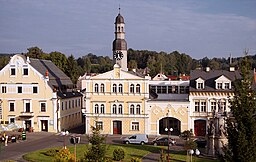
Chrastava
| Chrastava | |||
| Town | |||
|
Town Hall
|
|||
|
|||
| Country | Czech Republic | ||
|---|---|---|---|
| Region | Liberec | ||
| District | Liberec | ||
| Commune | Liberec | ||
| Municipality | Chrastava | ||
| Elevation | 295 m (968 ft) | ||
| Coordinates | 50°49′1″N 14°58′8″E / 50.81694°N 14.96889°ECoordinates: 50°49′1″N 14°58′8″E / 50.81694°N 14.96889°E | ||
| Area | 27.46 km2 (10.60 sq mi) | ||
| Population | 5,976 | ||
| Density | 218/km2 (565/sq mi) | ||
| First mentioned | 1352 | ||
| Mayor | Michael Canov | ||
| Timezone | CET (UTC+1) | ||
| - summer (DST) | CEST (UTC+2) | ||
| Postal code | 463 31 | ||
| Statistics: statnisprava.cz | |||
| Website: www.chrastava.cz | |||
Chrastava (Czech pronunciation: [ˈxrastava]; German: Kratzau) is a town in northern Bohemia in the Czech Republic about 10 kilometre (6 mi) northwest of the regional capital Liberec. The town is situated on the Jeřice brook near to its confluence with the Lusatian Neisse (Czech: Lužická Nisa). Chrastava is surrounded by hills of the Ještěd Mountains and more distant Jizera Mountains.
The town of Chrastava was first mentioned in 1351 as Craczauia. It was founded very probably in the end of the 13th century on the site of an older village of the West Slavic Milceni tribe by German settlers, having been invited by King Ottokar II of Bohemia. They came mainly from the city Pirna in Saxony.
Chrastava, then known mostly by the German name Kratzau, was occupied by the Hussites who use the town as a base for expeditions into Lusatia during the Hussite Wars. Kratzau was governed by the Habsburg Monarchy after Bohemia was inherited by the Austrian Habsburgs in 1526. It received town rights in 1527.
The town became a mining centre in 15th and 16th century, in particularly in copper, tin, lead, zinc, iron and silver mining. Two small mining towns, Andělská Hora (German: Engelsberg) and Panenská Hůrka (German: Frauenberg), were established by the miners more closely to the metal veins.
...
Wikipedia


