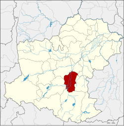
Chok Chai District
|
Chok Chai โชคชัย |
|
|---|---|
| Amphoe | |
 Amphoe location in Nakhon Ratchasima Province |
|
| Coordinates: 14°43′56″N 102°9′47″E / 14.73222°N 102.16306°ECoordinates: 14°43′56″N 102°9′47″E / 14.73222°N 102.16306°E | |
| Country | Thailand |
| Province | Nakhon Ratchasima |
| Seat | Chok Chai |
| Area | |
| • Total | 503.9 km2 (194.6 sq mi) |
| Population (2015) | |
| • Total | 81,632 |
| • Density | 146.2/km2 (379/sq mi) |
| Time zone | ICT (UTC+7) |
| Postal code | 30190 |
| Geocode | 3007 |
Chok Chai (Thai: โชคชัย) is a district (amphoe) in Nakhon Ratchasima Province, northeastern Thailand.
The district was originally named Kra Thok (กระโทก). The government renamed it Chok Chai (meaning 'lucky victory') in 1945. The name was chosen to commemorate the victory of King Taksin the Great over the warlord of Phimai after the fall of Ayutthaya.
Neighboring districts are (from the north clockwise) Mueang Nakhon Ratchasima, Chaloem Phra Kiat, Nong Bun Mak, Khon Buri and Pak Thong Chai.
Chok Chai is divided into 10 sub-districts (tambon), which are further subdivided into 132 administrative villages (muban).
There are three sub-district municipalities (thesaban tambon) in the district:
There are nine sub-district administrative organizations (SAO) in the district:
...
Wikipedia
