Chlef Province
|
Chlef Province البرواقية المدية |
|
|---|---|
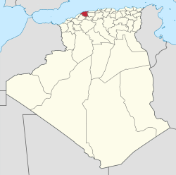
 Map of Algeria highlighting Chlef |
|
| Coordinates: 36°10′N 01°20′E / 36.167°N 1.333°ECoordinates: 36°10′N 01°20′E / 36.167°N 1.333°E | |
| Country |
|
| Capital | Chlef |
| Government | |
| • PPA president | Mohamed Meheni (FLN) |
| • Wāli | Mr. Mohamed El Ghazi |
| Area | |
| • Total | 4,975 km2 (1,921 sq mi) |
| Population (2008) | |
| • Total | 1,013,718 |
| • Density | 200/km2 (530/sq mi) |
| Time zone | CET (UTC+01) |
| Area Code | +213 (0) 27 |
| ISO 3166 code | DZ-02 |
| Districts | 13 |
| Municipalities | 35 |
| Website | wilaya-chlef.com |
Chlef (Arabic: ولاية الشلف, Berber: Tamnaḍt n Clef) is a province (wilaya) in Algeria, and has about 1 million inhabitants. Its capital is Chlef. Another locality is Ténès, on the Mediterranean Sea.
The province of Chlef is located at the Western Tell at 200 km west of Algiers.
The province is divided into 13 districts (daïras), which are further divided into 35 communes or municipalities.
...
Wikipedia
