Chincoteague Island, Virginia
| Chincoteague, Virginia | ||
|---|---|---|
| Town | ||

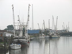
Fishing boats along the waterfront in Chincoteague
|
||
|
||
 Location in Accomack County and the state of Virginia. |
||
| Coordinates: 37°56′5″N 75°22′4″W / 37.93472°N 75.36778°WCoordinates: 37°56′5″N 75°22′4″W / 37.93472°N 75.36778°W | ||
| Country | United States | |
| State | Virginia | |
| County | Accomack | |
| Incorporated | 1908 | |
| Government | ||
| • Mayor | Arthur Leonard | |
| Area | ||
| • Total | 37.3 sq mi (96.7 km2) | |
| • Land | 9.1 sq mi (23.6 km2) | |
| • Water | 28.2 sq mi (73.1 km2) | |
| Elevation | 3 ft (1 m) | |
| Population (2010) | ||
| • Total | 2,941 | |
| • Density | 79/sq mi (30/km2) | |
| Time zone | Eastern (EST) (UTC-5) | |
| • Summer (DST) | EDT (UTC-4) | |
| ZIP code | 23336 | |
| Area code(s) | 757 | |
| FIPS code | 51-16512 | |
| GNIS feature ID | 1492764 | |
| Website | Official website | |
Chincoteague (/ˌʃɪŋkəˈtiːɡ/ or /ˈʃɪŋkətiːɡ/) is a town on Chincoteague Island in Accomack County, Virginia, U.S. The population was 2,941 at the 2010 census. The town is known for the Chincoteague Ponies, although these are not actually on the island of Chincoteague but on nearby Assateague Island. These ponies and the annual Pony Penning Day are the subject of Marguerite Henry's 1947 children's book Misty of Chincoteague, which was made into the 1961 family film Misty, filmed on location.
Chincoteague is located at 37°56′5″N 75°22′4″W / 37.93472°N 75.36778°W (37.934673, -75.367805). According to the United States Census Bureau, the town has a total area of 37.3 square miles (96.7 km2), of which 9.1 square miles (23.6 km2) is land and 28.2 square miles (73.1 km2), or 75.58%, is water.
...
Wikipedia

