Chiliques
| Chiliques (volcano) | |
|---|---|

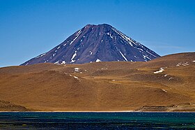
The Chiliques volcano, seen from Laguna Miscanti.
|
|
| Highest point | |
| Elevation | 5,778 m (18,957 ft) |
| Coordinates | 23°35′0″S 67°42′0″W / 23.58333°S 67.70000°W |
| Geography | |
| Location | Chile |
| Parent range | Andes |
| Geology | |
| Mountain type | Stratovolcano |
| Last eruption | Unknown |
Chiliques is a stratovolcano located in the Antofagasta Region of Chile.
Chiliques is capped off by a 500 metres (1,600 ft) wide summit crater, which contains two crater lakes. One of these lakes is found in the northern part and the other east-southeastern part. The volcano is formed by rocks ranging from andesite to dacite; the andesites of the main stratocone building phase contain pyroxene. Together with Tumisa, Leija and Cordón de Puntas Negras it forms a northwest-trending volcano alignment.
The first part of Chiliques to form was a block lava field, which still crops out northeast of the main volcano to a distance of 6.5 kilometres (4.0 mi). Lava flows with lengths of up to 10 kilometres (6.2 mi) then constructed the stratovolcano proper and were later buried by shorter (up to 5 kilometres (3.1 mi)) lava flows that cover a surface of 16.26 square kilometres (6.28 sq mi) around the summit crater. The Cerro Overo maar northeast of Chiliques is occasionally considered the last phase of Chiliques's activity, and the two have erupted rocks with similar chemical composition. There is no evidence for historical activity.
Over years, Chiliques has been monitored from space by ASTER imagery. In 2002, the imagery showed evidence of a temperature anomaly on Chiliques, which occasionally reached a scale of 15 °C (27 °F). This temperature anomaly may reflect either thermal events in crater lakes or fumarolic activity, although evidence for the occurrence of either is equivocal. Some of the anomalies were observed in the crater and others on the upper slopes of the volcano. This anomaly lasted only a few months, however.
Magnetotelluric investigation of the region has shown evidence of a high-conductivity structure underground between Chiliques, Cordón de Puntas Negras and Láscar. This high conductivity zone reaches a depth of 6 kilometres (3.7 mi) at its southern end, and it might reflect the presence of magma underground.
...
Wikipedia
