Chester, New Jersey
| Chester Borough, New Jersey | |
|---|---|
| Borough | |
| Borough of Chester | |

Downtown Chester
|
|
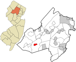
 Location in Morris County and the state of New Jersey. |
|
 Census Bureau map of Chester Borough, New Jersey |
|
| Coordinates: 40°47′26″N 74°41′24″W / 40.790536°N 74.689923°WCoordinates: 40°47′26″N 74°41′24″W / 40.790536°N 74.689923°W | |
| Country | |
| State |
|
| County | Morris |
| Incorporated | April 3, 1930 |
| Named for | Chestershire, England |
| Government | |
| • Type | Borough |
| • Body | Borough Council |
| • Mayor | Janet Hoven (R, term ends December 31, 2018) |
| • Administrator / Clerk | Valerie A. Egan |
| Area | |
| • Total | 1.596 sq mi (4.131 km2) |
| • Land | 1.594 sq mi (4.127 km2) |
| • Water | 0.002 sq mi (0.004 km2) 0.10% |
| Area rank | 442nd of 566 in state 37th of 39 in county |
| Elevation | 866 ft (264 m) |
| Population (2010 Census) | |
| • Total | 1,649 |
| • Estimate (2015) | 1,675 |
| • Rank | 507th of 566 in state 38th of 39 in county |
| • Density | 1,034.8/sq mi (399.5/km2) |
| • Density rank | 378th of 566 in state 28th of 39 in county |
| Time zone | Eastern (EST) (UTC-5) |
| • Summer (DST) | Eastern (EDT) (UTC-4) |
| ZIP code | 07930 |
| Area code(s) | 908 |
| FIPS code | 3402712580 |
| GNIS feature ID | 0885184 |
| Website | www |
Chester is a borough in Morris County, New Jersey, United States. As of the 2010 United States Census, the borough's population was 1,649, reflecting an increase of 14 (+0.9%) from the 1,635 counted in the 2000 Census, which had in turn increased by 421 (+34.7%) from the 1,214 counted in the 1990 Census.
Chester Township was established as a separate political entity on April 1, 1799, including the area of both the Township and the downtown settlement which came to be the Borough. The Borough of Chester was incorporated by an act of the New Jersey Legislature on April 3, 1930, based on the results of a referendum held on April 25, 1930, and is today a separate municipality surrounded entirely by Chester Township. The borough's name is derived from the township, which was named for Chestershire in England.
According to the United States Census Bureau, the borough had a total area of 1.596 square miles (4.131 km2), including 1.594 square miles (4.127 km2) of land and 0.002 square miles (0.004 km2) of water (0.10%).
The borough is completely surrounded by Chester Township, making it part of 21 pairs of "doughnut towns" in the state, where one municipality entirely surrounds another.
As of the 2010 United States Census, there were 1,649 people, 615 households, and 437.9 families residing in the borough. The population density was 1,034.8 per square mile (399.5/km2). There were 647 housing units at an average density of 406.0 per square mile (156.8/km2). The racial makeup of the borough was 90.78% (1,497) White, 1.03% (17) Black or African American, 0.49% (8) Native American, 2.30% (38) Asian, 0.00% (0) Pacific Islander, 3.21% (53) from other races, and 2.18% (36) from two or more races. Hispanic or Latino of any race were 13.46% (222) of the population.
...
Wikipedia
