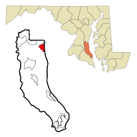
Chesapeake Beach, Maryland
| Chesapeake Beach, Maryland | |
|---|---|
| Town | |
| Town of Chesapeake Beach | |
| Nickname(s): "Twin Beaches" | |
 Location of Chesapeake Beach, Maryland |
|
| Coordinates: 38°41′42″N 76°32′10″W / 38.69500°N 76.53611°WCoordinates: 38°41′42″N 76°32′10″W / 38.69500°N 76.53611°W | |
| Country | |
| State |
|
| County |
|
| Government | |
| • Mayor | Bruce Wahl |
| Area | |
| • Total | 2.79 sq mi (7.23 km2) |
| • Land | 2.71 sq mi (7.02 km2) |
| • Water | 0.08 sq mi (0.21 km2) |
| Elevation | 49 ft (15 m) |
| Population (2010) | |
| • Total | 5,753 |
| • Estimate (2012) | 5,806 |
| • Density | 2,122.9/sq mi (819.7/km2) |
| Time zone | Eastern (EST) (UTC-5) |
| • Summer (DST) | EDT (UTC-4) |
| ZIP code | 20732 |
| Area code(s) | 301 |
| FIPS code | 24-15925 |
| GNIS feature ID | 0589951 |
Chesapeake Beach is a town in Calvert County, Maryland. Its major attractions include a Railway Museum & Trail, the Chesapeake Beach Water Park, marinas, piers, charter boat fishing, and a Veterans Memorial Park. The population was 5,753 at the 2010 census.
Chesapeake Beach is located at 38°41′42″N 76°32′10″W / 38.69500°N 76.53611°W (38.695070, -76.536125).
According to the United States Census Bureau, the town has a total area of 2.79 square miles (7.23 km2), of which, 2.71 square miles (7.02 km2) is land and 0.08 square miles (0.21 km2) is water.
The city has grown out from the intersection of Fishing Creek and the Chesapeake Bay. The creek has been dredged to allow pleasure craft, commercial fisherman and a few small US Navy vessels to dock in the city.
The southern end of the city remains heavily wooded and is distinguished by the large sandstone cliffs called the Randle Cliffs. These cliffs, and others along the Western Shore of the Chesapeake Bay, tower as high as 180 feet above the water and are constantly eroding due to freeze/thaw and wave action. The debris from these cliffs has formed a number of shallow sand bars which makes navigation by boat near the cliffs very difficult and the water very shallow for hundreds of yards into the Bay.
As of the census of 2010, there were 5,753 people, 2,134 households, and 1,520 families residing in the town. The population density was 2,122.9 inhabitants per square mile (819.7/km2). There were 2,354 housing units at an average density of 868.6 per square mile (335.4/km2). The racial makeup of the town was 84.8% White, 9.8% African American, 0.6% Native American, 1.4% Asian, 0.6% from other races, and 2.8% from two or more races. Hispanic or Latino of any race were 2.8% of the population.
...
Wikipedia
