Chesapeake Bay impact crater

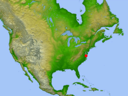
Location of impact site in relation to the United States
|
|
| Impact crater/structure | |
|---|---|
| Confidence | Confirmed |
| Diameter | 85 kilometres (53 mi) |
| Depth | 1.3 kilometres (0.81 mi) |
| Age | 35.5 ± 0.3 million |
| Exposed | No |
| Drilled | Yes |
| Location | |
| Location | Chesapeake Bay |
| Coordinates | 37°17′N 76°1′W / 37.283°N 76.017°WCoordinates: 37°17′N 76°1′W / 37.283°N 76.017°W |
| Country | United States |
| State | Virginia |
| Municipality | Cape Charles |
|
Location of impact site in Virginia
|
|
| Access | U.S. Route 13 to S.R. 184 |
The Chesapeake Bay impact crater was formed by a bolide that impacted the eastern shore of North America about 35.5 ± 0.3 million years ago, in the late Eocene epoch. It is one of the best-preserved "wet-target" or marine impact craters, and the largest known impact crater in the U.S.
Continued slumping of sediments over the rubble of the crater has helped shape the Chesapeake Bay.
During the warm late Eocene, sea levels were high, and the Tidewater region of Virginia lay in the coastal shallows. The shore of eastern North America, about where Richmond, Virginia, is today, was covered with dense tropical rainforest, and the waters of the gently sloping continental shelf were rich with marine life that was depositing dense layers of lime from their microscopic shells.
The bolide made impact at a speed of many kilometers per second, punching a deep hole through the sediments and into the granite continental basement rock. The bolide itself was completely vaporized, with the basement rock being fractured to depths of 8 km (5.0 mi), and a peak ring being raised around it. The deep crater, 38 km (24 mi) across, is surrounded by a flat-floored terrace-like ring trough with an outer edge of collapsed blocks forming ring faults.
The entire circular crater is about 85 km (53 mi) in diameter and 1.3 km (0.81 mi) deep, an area twice the size of Rhode Island, and nearly as deep as the Grand Canyon. However, numerical modeling techniques by Collins et al. indicate that the post-impact diameter was likely to have been around 40 km (25 mi), rather than the observed 85 km (53 mi).
...
Wikipedia

