Cheryomushki District
| Cheryomushki District | |
|---|---|
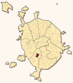
 Location of Cheryomushki District on the map of Moscow |
|
| Coordinates: 55°39′53″N 37°33′38″E / 55.66472°N 37.56056°ECoordinates: 55°39′53″N 37°33′38″E / 55.66472°N 37.56056°E | |
 Gazprom head office |
|
| Location | |
| Country | Russia |
| Federal subject | Moscow |
| Statistics | |
| Time zone | MSK (UTC+03:00) |
| Official website | |
| on | |
Cheryomushki District (Russian: райо́н Черёмушки, derived from "черёмуха", meaning "bird cherry tree"), formerly Brezhnevsky District, is a district of South-Western Administrative Okrug of the federal city of Moscow, Russia. Population: 102,619 (2010 Census);89,264 (2002 Census).
The district is delimited by Nakhimovsky Avenue (north), Obrucheva Street (south), Sevastopolsky Avenue (east), Profsoyuznaya Street, and Vlasova Street (west). The district is mostly residential, with an industrial area near Kaluzhskaya metro station. It houses the Gazprom headquarters.
In 1956, the northern side of the district became a site of a massive, cheap housing construction and a microdistrict was built there. Cheryomushki became a common word for such housing projects. The Soviet-era buildings in this area were torn down in the 1990s-2000s and replaced with high-rises, also of standardized prefabricated concrete.
Following the death of leader Leonid Brezhnev, the district was renamed Brezhnevsky District (Брежневский район) in his honour. In 1989 the name was changed back to Cheryomushki.
In the early 1980s, the government built a number of better quality, brickwork apartment buildings that acquired a reputation of, by local standards, elite housing, ironically called Tsarskoye Selo (Царское село, Royal village). In the 1990s, it served as a nucleus of a massive new housing construction project between Garibaldi Street and Gazprom tower.
...
Wikipedia
