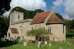
Checkendon
| Checkendon | |
|---|---|
 Parish church of Saints Peter and Paul |
|
| Checkendon shown within Oxfordshire | |
| Area | 9.85 km2 (3.80 sq mi) |
| Population | 493 (2011 census) |
| • Density | 50/km2 (130/sq mi) |
| OS grid reference | SU6683 |
| Civil parish |
|
| District | |
| Shire county | |
| Region | |
| Country | England |
| Sovereign state | United Kingdom |
| Postcode district | RG8 |
| Dialling code | 01491 |
| Police | Thames Valley |
| Fire | Oxfordshire |
| Ambulance | South Central |
| EU Parliament | South East England |
| UK Parliament | |
| Website | Checkendon Village |
Checkendon is a village and civil parish about 6 miles (10 km) west of Henley-on-Thames in South Oxfordshire and about 9 miles (14 km) north west of Reading in Berkshire on a mid-height swathe of the Chilterns.
The parish has a record of continuous settlement since the 7th century. It is listed in the Domesday Book as Cecadene (Old English for "Ceaca's hill or hill-pasture"). The parish covers about 1,500 hectares (3,700 acres) and lies between 150 metres (490 ft) and 170 metres (560 ft) above sea level.
After World War II Checkendon hosted a National Assistance Board camp for Polish war refugees displaced from Middle East and Africa. The camp, located at Checkendon outskirts was opened in 1948 and offered accommodation in Nissen huts and was closed in early 60's.
The Church of England parish church of Saint Peter and Saint Paul is a 12th-century Norman building. All but one of the windows were replaced later in the Middle Ages with Decorated Gothic and Perpendicular Gothic ones, and the Perpendicular Gothic west tower is also a later addition. The building is Grade I listed.
The church has an early 13th-century wall painting of Christ in Majesty above a procession of Apostles. The murals were faithfully repainted when they were rediscovered, but more recently this has been considered over-restoration.
...
Wikipedia

