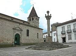
Chaves Municipality, Portugal
| Chaves, Portugal | |||
|---|---|---|---|
| Municipality | |||

Pelourinho Square
|
|||
|
|||
 |
|||
| Coordinates: 41°44′26″N 7°28′17″W / 41.74056°N 7.47139°WCoordinates: 41°44′26″N 7°28′17″W / 41.74056°N 7.47139°W | |||
| Country |
|
||
| Region | Norte | ||
| Subregion | Alto Trás-os-Montes | ||
| Intermunic. comm. | Alto Tâmega | ||
| District | Vila Real | ||
| Parishes | 41 (see text) | ||
| Government | |||
| • President | António Cândido Monteiro Cabeleira (PPD-PSD) | ||
| Area | |||
| • Total | 591.23 km2 (228.28 sq mi) | ||
| Elevation | 371 m (1,217 ft) | ||
| Population (2011) | |||
| • Total | 41,243 | ||
| • Density | 70/km2 (180/sq mi) | ||
| Time zone | WET/WEST (UTC+0/+1) | ||
| Postal code | 5400 | ||
| Area code | 276 | ||
| Patron | Nossa Senhora da Livração | ||
| Website | http://www.chaves.pt | ||
Chaves (Portuguese pronunciation: [ˈʃavɨʃ]) is a city and a municipality in the north of Portugal. It is 10 km south of the Spanish border and 22 km south of Verín (Spain). The population in 2011 was 41,243, in an area of 591.23 km². The municipality is the second most populous of the district of Vila Real (the district capital, Vila Real, is 60 km south on the A24 motorway). With origins in the Roman civitas Aquæ Flaviæ, Chaves has developed into a regional center. The urban area has 17,535 residents (2001).
Artefacts discovered in the region of Chaves identify the earliest settlement of humans dating back to the Paleolithic. Remnants discovered in Mairos, Pastoria and São Lourenço, those associated with transient proto-historic settlements and castros, show a human presence in the Alto Tâmega dating to the Chalcolithic. The region has seen persistent human settlement since Roman legions conquered and occupied the fertile valley of the Tâmega River, constructing a nascent outpost and taking over the existing castros in the area. The settlement was located at the convergence of three important Roman roads: the Bracara Augusta, Asturica, and Lamecum that crossed the Roman Province of Gallaecia, linking Rome to the region's natural resources. It was a military centre known for its baths, which lasted until the 16th century. This civilization constructed protective walls to protect the local population; spanned the river with the bridge; promoted the baths (with its warm medicinal waters); exploited local mines and alluvial deposits and other natural resources. Its importance led to the urban nucleus being elevated to the status ofmunicipality in 79 AD, during the reign of the first Flavian Caesar, Titus Flavius Caesar Vespasianus Augustus. Its benefactor consequently influenced its toponymy, becoming known as Aquae Flaviae. Artefacts from the area around the Matriz church indicate that Aquae Flaviae's centre was located in this place, in addition to an ancient headstone showing gladiatorial combat.
...
Wikipedia


