Chatham, New Hampshire
| Chatham, New Hampshire | |
|---|---|
| Town | |

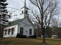
Chatham Congregational Church in Chatham village
|
|
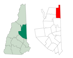
 Location in Carroll County, New Hampshire |
|
| Coordinates: 44°09′49″N 71°00′40″W / 44.16361°N 71.01111°WCoordinates: 44°09′49″N 71°00′40″W / 44.16361°N 71.01111°W | |
| Country | United States |
| State | New Hampshire |
| County | Carroll |
| Incorporated | 1767 |
| Government | |
| • Board of Selectmen | Bill Perry, Chair Wayne Infinger Jason Eastman |
| Area | |
| • Total | 57.2 sq mi (148.2 km2) |
| • Land | 56.7 sq mi (146.9 km2) |
| • Water | 0.5 sq mi (1.3 km2) 0.89% |
| Elevation | 521 ft (159 m) |
| Population (2010) | |
| • Total | 337 |
| • Density | 5.9/sq mi (2.3/km2) |
| Time zone | Eastern (UTC-5) |
| • Summer (DST) | Eastern (UTC-4) |
| ZIP code | 03813 |
| Area code(s) | 603 |
| FIPS code | 33-11780 |
| GNIS feature ID | 0873563 |
| Website | chathamnh |
Chatham is a town in Carroll County, New Hampshire, United States. The population was 337 at the 2010 census. It is located in the White Mountains, and except for the southeast corner, all of Chatham is in the White Mountain National Forest. The town is home to the Cold River national forest campgrounds.
Chatham was granted to Peter Livins and others, 7 February 1767, by colonial Governor Benning Wentworth. The town was named in honor of William Pitt, Earl of Chatham and Prime Minister of Great Britain, who had recently led Britain to victory in the Seven Years War. Chatham was regranted in 1770 by his nephew, Governor John Wentworth, to a group including Samuel Langdon, president of Harvard College and creator of the "Blanchard Map" of the North Country. Part of Conway was annexed in 1829.
According to the United States Census Bureau, the town has a total area of 57.2 square miles (148 km2), of which 56.7 sq mi (147 km2) is land and 0.5 sq mi (1.3 km2) (0.89%) is water. The highest point in Chatham is the summit of South Baldface, with an elevation of 3,547 feet (1,081 m) above sea level. Sable Mountain, elevation 3,519 ft (1,073 m), is in the west, and Robbins Ridge crosses the center of Chatham from east to west. Upper Kimball Pond is in the southeast, and Basin Pond in the northeast. Chatham lies fully within the Saco River watershed.
...
Wikipedia
