Charlevoix, Michigan
| Charlevoix, Michigan | |
|---|---|
| City | |

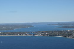
Aerial view of the town from above Lake Michigan; the small lake in the center is Round Lake and the larger one in the background is Lake Charlevoix.
|
|
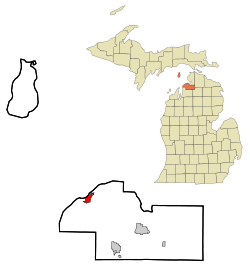
 Location in the state of Michigan |
|
| Coordinates: 45°19′5″N 85°15′30″W / 45.31806°N 85.25833°WCoordinates: 45°19′5″N 85°15′30″W / 45.31806°N 85.25833°W | |
| Country | United States |
| State | Michigan |
| County | Charlevoix |
| Government | |
| • Mayor | Norman (Boogie) Carlson |
| Area | |
| • Total | 2.17 sq mi (5.62 km2) |
| • Land | 2.05 sq mi (5.31 km2) |
| • Water | 0.12 sq mi (0.31 km2) |
| Elevation | 594 ft (181 m) |
| Population (2010) | |
| • Total | 2,513 |
| • Estimate (2012) | 2,520 |
| • Density | 1,225.9/sq mi (473.3/km2) |
| Time zone | EST (UTC-5) |
| • Summer (DST) | EDT (UTC-4) |
| ZIP codes | 49711, 49720 |
| Area code(s) | 231 |
| FIPS code | 26-14780 |
| GNIS feature ID | 0623115 |
| Website | http://www.cityofcharlevoix.org/ |
Charlevoix (/ˈʃɑːrləˌvɔɪ/ SHARL-ə-VOY) is a city in the U.S. state of Michigan. The population was 2,513 at the 2010 census. It is the county seat of Charlevoix County.
Charlevoix Township is a separate municipal entity that completely surrounds the city and has a year-round population of 1,697. Typical of Northern Michigan towns, Charlevoix has a much higher seasonal tourist population in the summer.
The city is situated between Lake Michigan and the western end of Lake Charlevoix, which drains into Lake Michigan through the short Round Lake/Pine River complex in the heart of downtown Charlevoix. The Charlevoix South Pier Light Station marks the opening of the channel onto Lake Michigan. Charlevoix's Round Lake has been called the best natural harbor on Lake Michigan. The only way to get from Lake Michigan to East Jordan, Boyne City and other sites on Lake Charlevoix by boat is via Charlevoix. As a result, much commercial, industrial, and recreational boat traffic passes through Charlevoix.
The city of Charlevoix has a U.S. Coast Guard station located in its vicinity. Station Charlevoix has served the waters of Lake Charlevoix and Lake Michigan for over one hundred years. The station was first sited in 1898 on the south break wall of the Pine River Channel, leading into Lake Michigan. It was officially commissioned as a United States Lifesaving Service Station July 5, 1900. During the early 1960s, the station was relocated to its present-day location along the Pine River Channel's Lake Charlevoix end. The area of response for Station Charlevoix runs from Cross Village down to Leland, extending into Lake Michigan through Beaver Island and the North and South Fox Islands, and covers numerous inland lakes and waterways. Spring through late fall the 41' UTB and the 25' RB-S are in operation and during the winter months, the 14' ice skiff is put into operation. There is also a U.S. Coast Guard Auxiliary Flotilla based at the Station. Some USCG Auxiliary surface facilities are occasionally moored at Station Charlevoix.
...
Wikipedia
