Charlestown Township, Clark County, Indiana
| Charlestown Township | |
|---|---|
| Township | |

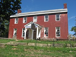
The John Work House, a historic site in the township
|
|
 Location of Charlestown Township in Clark County |
|
| Coordinates: 38°27′34″N 85°39′46″W / 38.45944°N 85.66278°WCoordinates: 38°27′34″N 85°39′46″W / 38.45944°N 85.66278°W | |
| Country | United States |
| State | Indiana |
| County | Clark |
| Government | |
| • Type | Indiana township |
| Area | |
| • Total | 65.09 sq mi (168.6 km2) |
| • Land | 64.49 sq mi (167.0 km2) |
| • Water | 0.6 sq mi (2 km2) |
| Elevation | 610 ft (186 m) |
| Population (2010) | |
| • Total | 13,450 |
| • Density | 208.6/sq mi (80.5/km2) |
| FIPS code | 18-12142 |
| GNIS feature ID | 453197 |
Charlestown Township is one of twelve townships in Clark County, Indiana. As of the 2010 census, its population was 13,450 and it contained 5,382 housing units.
Charlestown Township was organized in 1817.
According to the 2010 census, the township has a total area of 65.09 square miles (168.6 km2), of which 64.49 square miles (167.0 km2) (or 99.08%) is land and 0.6 square miles (1.6 km2) (or 0.92%) is water.
The township contains several cemeteries: Armstrong Cemetery, Baird Cemetery (a.k.a. King), Bottorff, Caldwell (a.k.a. Lutz/Prather), Carter, Charlestown, Coble, County Poor Farm, Crace, Douglas, Faris, Fifty-four, Goodwin, Goodwin/Nicholson, Hammond, Hester-Rowland, Kessler (a.k.a. Faris II), Long, Mathes, McCormick (a.k.a. McCullough), McDonald, Meloy, Montgomery, Otisco Cemetery (a.k.a. Seedtick), Pleasant Grove, Robertson, Robinson, Salem Methodist Church, Shelby Cemetery, Silver Creek Cemetery, St. Michael's, James Stuart Plantation, Weimer, and Worrell/Worrall.
...
Wikipedia
