Charlestown, New Hampshire
| Charlestown, New Hampshire | ||
|---|---|---|

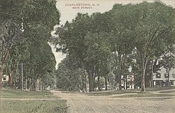
Main Street in 1910
|
||
|
||
 Location in Sullivan County and the state of New Hampshire |
||
| Coordinates: 43°14′04″N 72°25′28″W / 43.23444°N 72.42444°WCoordinates: 43°14′04″N 72°25′28″W / 43.23444°N 72.42444°W | ||
| Country | United States | |
| State | New Hampshire | |
| County | Sullivan | |
| Incorporated | 1783 | |
| Government | ||
| • Board of Selectmen | Art Grenier, Chair Steven Neill Thomas Cobb |
|
| Area | ||
| • Total | 38.0 sq mi (98.5 km2) | |
| • Land | 35.8 sq mi (92.7 km2) | |
| • Water | 2.2 sq mi (5.8 km2) 5.90% | |
| Elevation | 384 ft (117 m) | |
| Population (2010) | ||
| • Total | 5,114 | |
| • Density | 55.2/sq mi (21.3/km2) | |
| Time zone | Eastern (UTC-5) | |
| • Summer (DST) | Eastern (UTC-4) | |
| ZIP code | 03603 | |
| Area code(s) | 603 | |
| FIPS code | 33-11380 | |
| GNIS feature ID | 0873562 | |
| Website | www |
|
Charlestown is a town in Sullivan County, New Hampshire, United States. The population was 5,114 at the 2010 census. The town is home to Hubbard State Forest and the headquarters of the Student Conservation Association.
The primary settlement in town, where 1,152 people resided at the 2010 census, is defined as the Charlestown census-designated place (CDP) and is located along New Hampshire Route 12. The town also includes the villages of North Charlestown, South Charlestown and Hemlock Center.
The area was first granted on 31 December 1735 by colonial governor Jonathan Belcher of Massachusetts as "Plantation No. 4", the fourth in a line of forts on the Connecticut River border established as trading posts. Settled in 1740, Number Four was the northernmost township, and its 1744 log fort became a strategic military site throughout the French and Indian Wars. On the evening of May 2, 1746, Seth Putnam joined Major Josiah Willard and several soldiers as they escorted women to milk the cows. As they approached the booth, Natives hiding in the bushes opened fire, killing Putnam. This was the first casualty in the hostilities that would lead to the French and Indian War. In 1747 the fort was besieged for three days by a force of 400 French and Native people. Captain Phineas Stevens and 31 soldiers, stationed at the fort, repelled the attack. Their success became well-known, and the fort was never attacked again.
On July 2, 1753, the town was regranted as "Charlestown" by Governor Benning Wentworth, after Admiral Charles Knowles of the Royal Navy, then governor of Jamaica. Admiral Knowles, in port at Boston during the 1747 siege, sent Captain Stevens a sword to acknowledge his valor. The town responded by naming itself in his honor.
...
Wikipedia

