Charette, Quebec
| Charette | |
|---|---|
| Municipality | |

Church Notre-Dame-des-Neiges
|
|
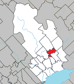
 Location within Maskinongé RCM. |
|
| Location in central Quebec. | |
| Coordinates: 46°27′N 72°56′W / 46.450°N 72.933°WCoordinates: 46°27′N 72°56′W / 46.450°N 72.933°W | |
| Country |
|
| Province |
|
| Region | Mauricie |
| RCM | Maskinongé |
| Settled | c. 1875 |
| Constituted | February 9, 1918 |
| Government | |
| • Mayor | Guy Diamond |
| • Federal riding | Berthier—Maskinongé |
| • Prov. riding | Maskinongé |
| Area | |
| • Total | 42.20 km2 (16.29 sq mi) |
| • Land | 41.52 km2 (16.03 sq mi) |
| Population (2011) | |
| • Total | 993 |
| • Density | 23.9/km2 (62/sq mi) |
| • Pop 2006-2011 |
|
| • Dwellings | 479 |
| Time zone | EST (UTC−5) |
| • Summer (DST) | EDT (UTC−4) |
| Postal code(s) | G0X 1E0 |
| Area code(s) | 819 |
| Highways |
|
| Website | www -charette |
Charette is a municipality of about 1000 people located in Maskinongé Regional County Municipality, in Quebec, Canada.
Charette is named in honour of one of its first settlers, Édouard Charette, originally from Sainte-Ursule, who built a saw mill and flour mill around 1875. In 1910, the post office opened and in 1918, the Municipality of Charette was established when the Parish of Notre-Dame-des-Neiges (formed in 1914) was incorporated. Its railway station identified the place with the English name of Charette's Mills for a period of time.
On December 31, 2001, Charette was added to the Maskinongé RCM when Le Centre-de-la-Mauricie Regional County Municipality was dissolved.
Population trend:
Private dwellings occupied by usual residents: 442 (total dwellings: 479)
Mother tongue:
The mayor is the municipality's highest elected official. Charette has had fourteen mayors. Officially, municipal elections in Charette are on a non-partisan basis.
...
Wikipedia

