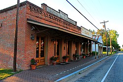
Chappell Hill, Texas
| Chappell Hill, Texas | |
|---|---|
| unincorporated community | |
 |
|
 Location of Chappell Hill, Texas |
|
| Coordinates: 30°08′07″N 96°15′25″W / 30.13528°N 96.25694°WCoordinates: 30°08′07″N 96°15′25″W / 30.13528°N 96.25694°W | |
| Country | United States |
| State | Texas |
| County | Washington |
| Area | |
| • Water | 0.0 sq mi (0.0 km2) |
| Population (2000) | |
| • Total | 600 |
| Time zone | Central (CST) (UTC-6) |
| • Summer (DST) | CDT (UTC-5) |
| ZIP code | 77426 |
| Area code(s) | 979 |
Chappell Hill is a small rural unincorporated community in the eastern portion of Washington County, Texas, United States. It is located along U.S. Highway 290 roughly halfway between Brenham and Hempstead. Chappell Hill is located inside Stephen F. Austin's original colony, and the land is some of the oldest Anglo-settled in the state.
Chappell Hill is located at the junction of US Route 290 and Farm to Market Road 1155. Chappell Hill is located within the Brazos River watershed. The area is part of the Gulf Coastal Plain, and the terrain is rolling hills.
The town was established in 1849 by Mary Elizabeth Haller (née Hargrove; 1827–1867), who founded the town on 100 acres (0.40 km2) of land she bought and having opened a post office two years earlier. She then named the town after her maternal grandfather Robert Wooding Chappell. The area around the town was settled by planters from the Deep South and, thanks to the fertile soil of the Brazos River valley, cotton became the area's main crop.
Jacob Haller (d. 1853) and Mary built in 1850 a large home which served as a boarding house and then became the Stage Coach Inn, which Mary or her mother Charlotte Hargrove (1804–1879) operated until 1859, continuing under new ownership until 1871. Because the inn was about halfway between Houston and Austin, it was a convenient stopover for travelers along two major stagecoach lines.
...
Wikipedia
