Chanhassen
| Minneapolis, Minnesota | |
|---|---|
| City | |
| City of Chanhassen | |
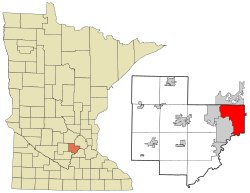
 Location of the city of Chanhassen within Carver County, Minnesota |
|
| Coordinates: 44°51′44″N 93°31′50″W / 44.86222°N 93.53056°WCoordinates: 44°51′44″N 93°31′50″W / 44.86222°N 93.53056°W | |
| Country | United States |
| State | Minnesota |
| Counties | Carver, Hennepin |
| Government | |
| • Mayor | Denny Laufenburger |
| Area | |
| • Total | 22.88 sq mi (59.26 km2) |
| • Land | 20.44 sq mi (52.94 km2) |
| • Water | 2.44 sq mi (6.32 km2) |
| Elevation | 974 ft (295 m) |
| Population (2010) | |
| • Total | 22,952 |
| • Estimate (2015) | 25,332 |
| • Density | 1,122.9/sq mi (433.6/km2) |
| Time zone | CST (UTC-6) |
| • Summer (DST) | CDT (UTC-5) |
| ZIP code | 55317 |
| Area code(s) | 952 |
| FIPS code | 27-10918 |
| GNIS feature ID | 0641106 |
| Website | City of Chanhassen |
Chanhassen is a city in Carver and Hennepin counties in the state of Minnesota. It is southwest of Minneapolis. The population was 22,952 at the 2010 census.
The origin of the name comes from the Dakota word chanhasen meaning "sugar-maple tree" (chan, tree; haza, a tree with sap). The northern metro area Hassan Township carries the latter syllable of the word to avoid confusion. Chanhassen was ranked as the #2 best place to live in America in 2009 by Money Magazine, and fourth among small towns rated as best places to live in 2013.
Chanhassen is located at 44°51′44″N 93°31′50″W / 44.86222°N 93.53056°W.
According to the United States Census Bureau, the city has a total area of 22.88 square miles (59.26 km2), of which 20.44 square miles (52.94 km2) is land and 2.44 square miles (6.32 km2) is water. Although the bulk of Chanhassen is in Carver County, a small portion also extends into Hennepin County.
U.S. Highway 212 and Minnesota State Highways 5 and 41 are three of the main routes in Chanhassen.
Township 116 North, Range 23 West, Fifth Principal Meridian of the Public Land Survey System.
...
Wikipedia
