Champvent
| Champvent | ||
|---|---|---|
 |
||
|
||
| Coordinates: 46°47′N 6°34′E / 46.783°N 6.567°ECoordinates: 46°47′N 6°34′E / 46.783°N 6.567°E | ||
| Country | Switzerland | |
| Canton | Vaud | |
| District | Jura-Nord Vaudois | |
| Government | ||
| • Mayor | Syndic | |
| Area | ||
| • Total | 9.04 km2 (3.49 sq mi) | |
| Elevation | 530 m (1,740 ft) | |
| Population (Dec 2015) | ||
| • Total | 616 | |
| • Density | 68/km2 (180/sq mi) | |
| Postal code | 1443 | |
| SFOS number | 5905 | |
| Surrounded by | Baulmes, Essert-sous-Champvent, Mathod, Orges, Rances, Suscévaz, Valeyres-sous-Montagny, Villars-sous-Champvent, Vuiteboeuf | |
| Website |
http://www.champvent.ch Profile (French), SFSO statistics |
|
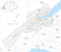
Champvent is a municipality in the district of Jura-Nord Vaudois of the canton of Vaud in Switzerland. The municipalities of Essert-sous-Champvent and Villars-sous-Champvent merged on 1 January 2012 into Champvent.
Champvent is first mentioned in 1011 as Canvent. In 1013 it was mentioned as Canventum and in 1228 as Chanvent.
Champvent has an area, as of 2009[update], of 6.9 square kilometers (2.7 sq mi). Of this area, 4.77 km2 (1.84 sq mi) or 68.9% is used for agricultural purposes, while 1.77 km2 (0.68 sq mi) or 25.6% is forested. Of the rest of the land, 0.3 km2 (0.12 sq mi) or 4.3% is settled (buildings or roads), 0.01 km2 (2.5 acres) or 0.1% is either rivers or lakes and 0.02 km2 (4.9 acres) or 0.3% is unproductive land. After the merger, the total area was 9.04 km2 (3.49 sq mi).
Of the built up area, housing and buildings made up 1.9% and transportation infrastructure made up 2.2%. Out of the forested land, 24.1% of the total land area is heavily forested and 1.4% is covered with orchards or small clusters of trees. Of the agricultural land, 56.8% is used for growing crops and 10.1% is pastures, while 2.0% is used for orchards or vine crops. All the water in the municipality is flowing water.
The municipality was part of the Yverdon District until it was dissolved on 31 August 2006, and Champvent became part of the new district of Jura-Nord Vaudois.
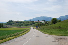
The municipality is located at the foot of the Jura Mountains. It consists of the village of Champvent, the hamlet of Saint-Christophe and the enclave of Mornens.
The blazon of the municipal coat of arms is Paly Argent and Azure with Fess enhanced in Gules surmounting.
...
Wikipedia


