Champoeg, Oregon
| Champoeg, Oregon | |
|---|---|
| Ghost town | |

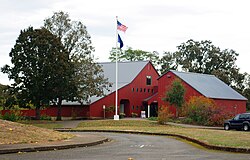
Museum at the state heritage area
|
|
 Location near neighboring cities |
|
| Location within the state of Oregon | |
| Coordinates: 45°14′56″N 122°53′49″W / 45.24889°N 122.89694°WCoordinates: 45°14′56″N 122°53′49″W / 45.24889°N 122.89694°W | |
| Country | United States |
| State | Oregon |
| County | Marion |
| Time zone | Pacific (PST) (UTC-8) |
| • Summer (DST) | PDT (UTC-7) |
| ZIP code | 97137 |
| Area code(s) | 503 and 971 |
| Website | http://www.champoeg.org/ |
|
Champoeg State Park Historic Archeological District
|
|
| Nearest city | St. Paul, Oregon |
|---|---|
| Built | 1830 |
| NRHP Reference # | 84003038 |
| Added to NRHP | August 01, 1984 |
Champoeg (/ʃæmˈpuːiː/ sham-POO-ee, historically /ʃæmˈpuːɛɡ/ sham-POO-eg) is a former town in the U.S. state of Oregon. Now a ghost town, it was an important settlement in the Willamette Valley in the early 1840s. Located halfway between Oregon City and Salem, it was the site of the first provisional government of the Oregon Country.
The town site is on the south bank of the Willamette River in northern Marion County, approximately 5 mi (8 km) southeast of Newberg. The town is now part of Champoeg State Heritage Area, an Oregon state park. The Champoeg State Park Historic Archeological District is within the heritage area.
...
Wikipedia


