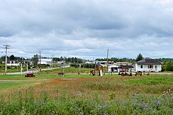
Champneuf, Quebec
| Champneuf | |
|---|---|
| Municipality | |
 |
|
 Location within Abitibi RCM. |
|
| Location in western Quebec. | |
| Coordinates: 48°35′N 77°30′W / 48.583°N 77.500°WCoordinates: 48°35′N 77°30′W / 48.583°N 77.500°W | |
| Country |
|
| Province |
|
| Region | Abitibi-Témiscamingue |
| RCM | Abitibi |
| Settled | 1938 |
| Constituted | January 1, 1964 |
| Government | |
| • Mayor | Rosaire Guénette |
| • Federal riding | Abitibi—Témiscamingue |
| • Prov. riding | Abitibi-Ouest |
| Area | |
| • Total | 240.50 km2 (92.86 sq mi) |
| • Land | 242.39 km2 (93.59 sq mi) |
| There is an apparent contradiction between two authoritative sources |
|
| Population (2011) | |
| • Total | 127 |
| • Density | 0.5/km2 (1/sq mi) |
| • Pop 2006-2011 |
|
| • Dwellings | 56 |
| Time zone | EST (UTC−5) |
| • Summer (DST) | EDT (UTC−4) |
| Postal code(s) | J0Y 1E0 |
| Area code(s) | 819 |
| Highways | No major routes |
Champneuf is a municipality in the Canadian province of Quebec, located in the Abitibi Regional County Municipality. It is the smallest incorporated place in terms of population in the Abitibi-Témiscamingue region.
In 1938, the settlement was founded, first called Colonie Bertrand, after its first parish priest Achille-Augustin Bertrand. In 1941, it was renamed to Champneufs (French for "new fields"), but also known by the parish name of Saint-François-d'Assise-de-Champneufs during the 1950s. At one point and for unknown reasons, the name was changed from the plural to the singular Champneuf. In 1964, the place was incorporated as a municipality.
Population trend:
Private dwellings occupied by usual residents: 50 (total dwellings: 56)
Mother tongue:
Climate type is dominated by the winter season, a long, bitterly cold period with short, clear days, relatively little precipitation mostly in the form of snow, and low humidity. The Köppen Climate Classification subtype for this climate is "Dfc"(Continental Subarctic Climate).
...
Wikipedia

