Chadakoin River
| Chadakoin | |
| River | |
| Name origin: Seneca for 'the rapids' | |
| Country | United States |
|---|---|
| State | New York |
| Tributaries | |
| - left | Cassadaga Creek |
| River | Allegheny River System |
| Source | Chautauqua Lake |
| - elevation | 1,308 ft (399 m) |
| - coordinates | 42°6′42″N 79°16′14″W / 42.11167°N 79.27056°W |
| Source confluence | Cassadaga Creek |
| - location | Falconer, New York |
| - elevation | 1,257 ft (383 m) |
| - coordinates | 42°7′54″N 79°10′48″W / 42.13167°N 79.18000°W |
| Mouth | Conewango Creek |
| - location | Frewsburg, New York |
| - elevation | 1,238 ft (377 m) |
| - coordinates | 42°5′30″N 79°8′11″W / 42.09167°N 79.13639°WCoordinates: 42°5′30″N 79°8′11″W / 42.09167°N 79.13639°W |
| Length | 7.8 mi (13 km) |
| Basin | 192 sq mi (497 km2) |
| Discharge | for Falconer, 1.8 miles (2.9 km) upstream from mouth |
| - average | 370 cu ft/s (10 m3/s) |
| - max | 2,250 cu ft/s (64 m3/s) (September 14, 1979) |
| - min | 0 cu ft/s (0 m3/s) (July 30, 2011) |
|
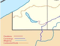
Chadakoin River (red)
|
|
The Chadakoin River is a 7.8-mile-long (12.6 km) stream that is a tributary of the Conewango Creek. The Chadakoin lies entirely in Chautauqua County in Western New York in the United States.
The stream drains an area of 192 square miles (500 km2), covering much of Chautauqua County. The creek begins at the southern end of Chautauqua Lake. Its watershed is bounded to the north by the Chautauqua Ridge, a continental divide that results in the water flowing eventually to the Gulf of Mexico rather than the nearby Great Lakes.
Flowing entirely within Chautauqua County, New York, the Chadakoin River begins by emptying Chautauqua Lake at Celoron. It then flows generally eastward through the City of Jamestown to Falconer where it is joined by a major tributary, Cassadaga Creek, four miles (6.4 km) east of Jamestown. The river then flows south to Frewsburg where it empties into the Conewango Creek, which then flows southward into Pennsylvania and joins the Allegheny River at the city of Warren, Pennsylvania.
Warner Dam, at Washington Street in Jamestown, controls the level of Chautauqua Lake and the flow of the Chadakoin. There is a five-foot-high (1.5 m) weir at Buffalo Street in Jamestown.
Little is known about the indigenous population around the river prior to the 17th century; it was likely inhabited by either the Erie or the Wenro. Étienne Brûlé, the first European to explore the area, did not document what tribes lived there at the time. The Seneca people, of the Iroquois League, invaded the region in the 1650s as part of the Beaver Wars. The Chadakoin was part of their water route system that connected the Great Lakes and Canada with Pennsylvania and destinations further south.
...
Wikipedia

