Chachoengsao province
|
Chachoengsao ฉะเชิงเทรา |
||
|---|---|---|
| Province | ||
|
||
| Nickname(s): Paet Rio | ||
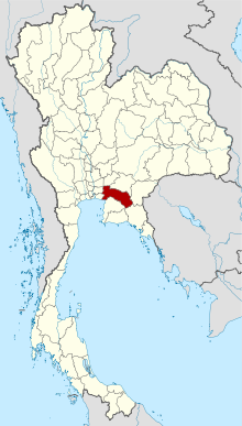
 Map of Thailand highlighting Chachoengsao Province |
||
| Country |
|
|
| Capital | Chachoengsao town | |
| Government | ||
| • Governor | Anukun Tangkhananukunchai (since October 2013) | |
| Area | ||
| • Total | 5,351 km2 (2,066 sq mi) | |
| Area rank | Ranked 41st | |
| Population (2015) | ||
| • Total | 700,902 | |
| • Rank | Ranked 37th | |
| • Density rank | Ranked 39th | |
| Time zone | ICT (UTC+7) | |
| ISO 3166 code | TH-24 | |
Chachoengsao (Thai: (Pronunciation)) is a province (changwat) of Thailand. Neighboring provinces are (from north clockwise) Prachin Buri, Sa Kaeo, Chanthaburi, Chon Buri, Samut Prakan, Bangkok, Pathum Thani, and Nakhon Nayok. It has a short coastline on the Gulf of Thailand.
Chachoengsao or Paet Riu is a province in eastern Thailand. It has a history dating back to the reign of King Borommatrailokkanat in the Ayutthaya period. People originally settled by the Bang Pakong River and along canals.
"Luangpho Phuttha Sothon" is a centre of faith of the people of Paet Riu.
In the past, Chachoengsao was a fourth-class city under the ministry of defence. In 1916, its status was changed from a city to a province.
The west part of the province is the low river plain of the Bang Pa Kong River, which is used extensively for farming rice. To the east is hillier terrain, with an average height of more than 100 m above sea level.
The provincial seal shows the main hall of the Sothornvararamvoraviharn temple. In this hall is the most important Buddha image of the province, known as Luangpho Phutthasothon.
The provincial tree is Peltophorum dasyrachis. The tree was assigned to the province by Queen Sirikit on the 50th anniversary of the coronation of King Rama IX in 2000. The provincial flower is the Yellow Flamboyant (Peltophorum pterocarpum).
...
Wikipedia

