Chaîne de l'Épine
| Chaîne de l'Épine | |
|---|---|

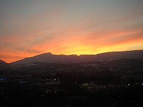
Sunset over the Chain de l'Épine ridge seen from Chambéry in Savoie, France.
|
|
| Highest point | |
| Elevation | 1,425 m (4,675 ft) |
| Coordinates | 45°34′52″N 5°49′23″E / 45.58111°N 5.82306°ECoordinates: 45°34′52″N 5°49′23″E / 45.58111°N 5.82306°E |
| Geography | |
| Location | Savoie, Rhône-Alpes, France |
| Parent range | Jura Mountains |
| Geology | |
| Age of rock |
Jurassic and Cretaceous deposits Miocene formation |
| Mountain type | Limestone fold mountain |
The Chaîne de l'Épine, in the department of Savoie in southeast France, is a 20-kilometre (12 mi) long ridge of the Jura Mountains that runs north–south along the east side of the Lac d'Aiguebelette, from the Col de l'Épine west of Chambéry as far as the western edge of the Chartreuse Mountains, near the commune of Les Échelles. To the north, the ridge becomes the Mont du Chat ridge along the western shore of the Lac du Bourget. At the southern end, the ridge terminates at the Guiers River.
There are two explanations for the origin of the name "Chaîne de l'Épine". One traces "l'Épine" as a reference to a thorn from Christ's crown of thorns that Guillaume de Montbel brought back with him on his return from the Seventh Crusade in 1254. Montbel built the Château de l'Épine on the ridge above Nances and placed the holy thorn relic in the castle's chapel. In time, the chapel became such an important pilgrimage site that the name "l'Épine" was given to the whole mountain. The second explanation sees the Celtic god Pen as the source for both the name of the Chaîne de l'Épine ridge and the commune of Lépin-le-Lac to its west.
The Chaîne de l'Épine and the Mont du Chat separate the Lac du Bourget (to the east and north) from the Lac d'Aiguebelette (to the west and south). The highest point is Mont Grelle at an elevation of 1,425 metres (4,675 ft). Another notable peak is 1,232-metre (4,042 ft) Gratte-Cul at the northern end of Mont Grelle.
...
Wikipedia

